Resource Issues: Marine Protected Areas
California's Marine Protected Areas
California leads the nation in ocean protection
Millions of acres of our nation's natural heritage are protected through our system of national parks, national forests and wilderness areas. California is now leading the nation in conserving our ocean heritage by creating a statewide system of marine protected areas (MPAs).
As parks protect wildlife and habitats on land, MPAs protect the ocean. They help ensure that the ocean's bounty and beauty are protected and maintained for future generations to use and enjoy.
Marine protected areas are a tool for ocean protection
MPAs are special places where human activities are carefully managed. They vary in size and allow different types of use depending upon their conservation goals. Some are designed to protect large ocean ecosystems. Others may safeguard a particular fishery, rare species, critical habitat for marine life, or underwater historical sites.
MPAs differ in what they allow and prohibit inside their boundaries. Some may be "no take" areas that prohibit all fishing, drilling, mining and other extractive activities. Others may allow some commercial and recreational fishing. Most MPAs allow research, education and recreational activities like kayaking, surfing or diving.
What can MPAs do?
- MPAs can preserve marine habitats in their natural state.
- If MPAs are healthier and more resilient than disturbed areas, then they may be able to recover more quickly from stresses like climate change, pollution or severe storms.
- MPAs can provide places where scientists monitor changes in ocean health and determine if they are natural or human-caused.
- MPAs can provide recreation, education and economic opportunities.
 MPAs play a significant role in ocean protection worldwide
Marine protected areas are found throughout the world. Within the United States, our national marine sanctuaries help protect some of our nation's healthiest and most scenic ocean areas. They support research, education, preserve natural and cultural resources, and serve as natural classrooms and recreational areas.
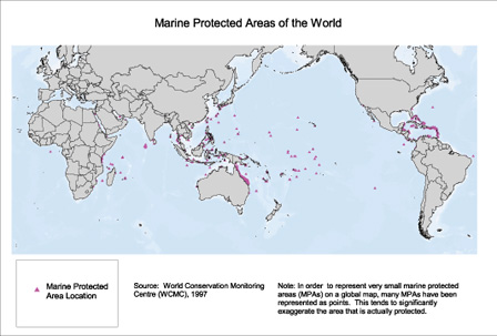 |
| Marine protected areas are used as a tool for ocean protection worldwide. |
|
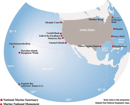 |
| National Marine Sanctuaries preserve the natural and cultural features of 14 underwater parks ranging from America Samoa to the Florida Keys. |
California is the first state in the nation to create a statewide network of MPAs
 In 1999 the Marine Life Protection Act (MLPA) was enacted, directing the state to design and manage a network of marine protected areas.
Based on sound science, public involvement, and careful planning, the MPA network is designed to protect a variety of critical ocean habitats. As refuges for marine life, MPAs will complement other state conservation efforts by allowing marine ecosystems to recover and thrive.
Design and management of the statewide MPA network California Department of Fish and Wildlife is the state agency responsible for implementing and managing the network. The California coast has been divided into five planning regions. Each region will undertake a collaborative public process to designate MPAs in their area. People knowledgeable about ocean uses and resources such as fishermen, conservationists and scientists will participate in the design process for their region.
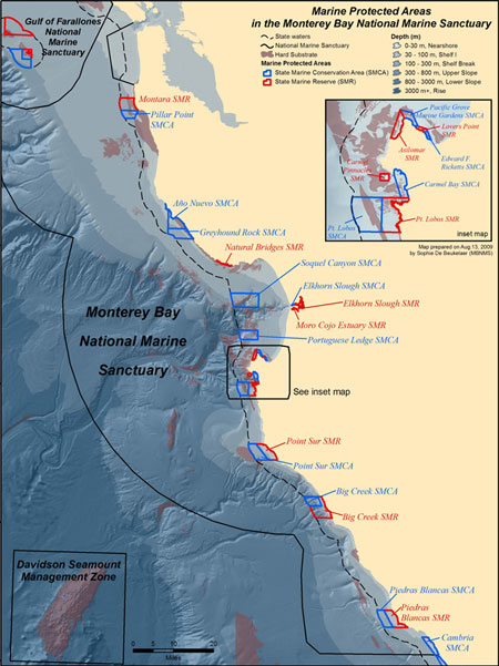
Central Coast MPAs
The central coast was the first region to complete a network in 2007 when 29 MPAs were designated along its shores. The central coast network covers 204 square miles (about 18%) of state waters from Pigeon Point to Point Conception, including 85 square miles (about 7.5%) of fully protected marine reserves. Other important areas, like Soquel Canyon and Carmel Bay, allow the take of selected species while protecting most.
< class="std12">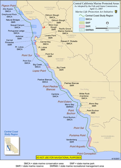
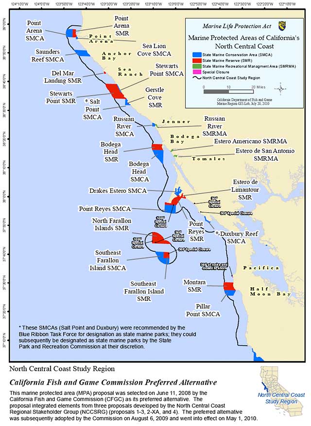
North Central Coast MPAs
In 2009 the north central coast became the second region to complete a network. A suite of 24 new MPAs covering 153 square miles (20.1%) of state waters now extends from Alder Creek (near Point Arena) to Pigeon Point. Approximately 86 square miles (11%) are designated as "no take" marine reserves.
Additional MPAs established to the north and south will create a statewide network along the entire California coast.
From seashore to seafloor, California MPAs protect a variety of habitats
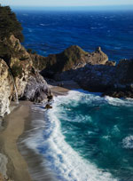
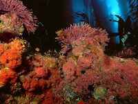
< class="std12">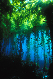 To protect the greatest diversity of life, the state network of MPAs includes a portion of every marine habitat found along our coast, from sheltered estuaries and lush kelp forests to steep underwater canyons. 11-12. kelp forest and slough habitats
How do MPAs restore and protect habitats?
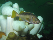
When parts of the ocean are set aside from as much disturbance as possible, the whole web of life benefits. Inside many MPAs, scientists have seen an increase in the size, abundance and diversity of some kinds of marine life.
Networks of MPAs, like those being created by the State of California, provide even greater protection. Because they include a diversity of habitats, they also help preserve the connections and flow of life between habitats vital to healthy marine ecosystems.
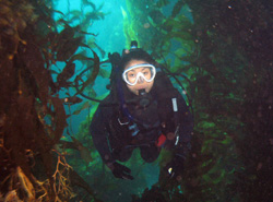
Researchers are now studying central California's MPAs with the help of scuba divers, fishermen, submarines and remotely operated vehicles. They want to find out if these areas are succeeding in conserving habitats and marine life over time.
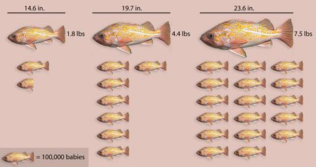 |
| Scientists have found that rockfish living inside a "no-take" marine reserve can double their population size and grow 30% larger than those outside a reserve. A 23-inch vermilion rockfish can produce 17 times more young than a 14-inch fish! |
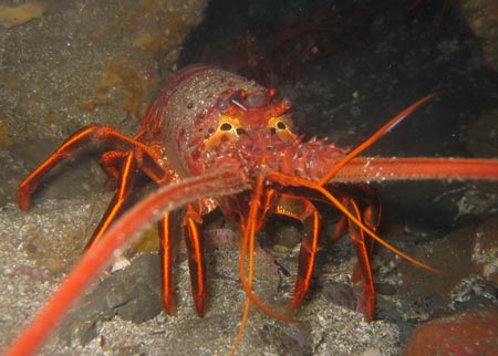 |
| Inside marine protected areas established around California's Channel Islands in 2003, spiny lobsters have already become more abundant. |
MPA activities and opportunities
 Our state's new MPAs provide economic, recreational and environmental benefits to Californians, whether they live on the water's edge or far inland. MPAs can improve ecotourism opportunities such as bird and marine mammal watching, kayaking and scuba diving. And healthy marine habitats can provide more sustainable livelihoods for local residents of communities that rely on the sea.
The MBNMS is supporting management of central California's marine protected areas
Most of the central coast and north central coast networks of state-designated MPAs reside within the boundaries of the sanctuary, and we are assisting the California Department of Fish and Game with their management.
Along with our partners, we are supporting a variety of monitoring and data collection projects in state-designated MPAs. These range from monitoring key habitats such as kelp forests, rocky shores and soft bottom communities, as well as individual populations of fishes and invertebrates (like black abalone), to monitoring the quality of water. We are also collecting important geologic and oceanographic data and studying the impacts of lost fishing gear in MPAs. For more detailed information about MPA research projects, visit our MPA registry.
A natural resource law enforcement group organized by the MBNMS and comprised of representatives of all federal, state, and local government authorities shares information and plans joint patrols focused on enforcement of new MPA regulations. MBNMS also facilitates joint interagency patrols involving aerial, boat, and land-based personnel and assets. In addition to monitoring activities from our R/V Fulmar, we also use a NOAA Twin Otter aircraft to observe vessel activity and ensure compliance with the new MPA regulations.
Various projects to educate the public about state MPAs have included the development of shoreline signs, production of a traveling exhibit for interpretive centers, trainings for docent groups and guided field trips for families at different MPA locations. Public Service Announcements as well as videos are being developed that can be used for training purposes or presented at local visitor centers and other locations. The development of additional outreach products, including media, print materials and signs, is ongoing.
Learn more about marine protected areas!
- For high quality educational materials found here were developed in close collaboration with many partner organizations visit, the California's Marine Protected Areas Education and Outreach Initiative.
- This Google Tour explores Monterey Bay National Marine Sanctuary and the 29 MPAs along California's central coast with breathtaking pictures and videos and links to nearby activities to enjoy these special ocean areas.
- Stay informed. Get connected to agencies and organizations involved in MPAs. For a directory, visit NOAA's National Marine Protected Areas website.
- Voice your opinions! Share your ideas about MPAs with friends, family and government officials, and encourage them to do the same. For a directory of elected officials, visit: USA.gov or Congress.org
- Participate in state and federal processes to establish new MPAs. For information, visit the California Department Fish and Game website or the National Marine Protected Areas website.
- OceanSpaces
- Perspectives on MLPA Implementation and Governenance (YouTube video)
- State of the California Central Coast: Results from Baseline Monitoring of Marine Protected Areas 2007–2012