
A. Oil spills
Oil spills are the most dramatic potential human impact to rocky shores, and have received considerable popular and scientific attention (e.g. National Research Council 1985, Foster et al. 1988, Davidson 1990, De Vogelaere and Foster 1994). Oil spills can cause large-scale disturbances, but it is difficult to generalize about their damage because spills vary greatly in amount, chemical composition, and degree of weathering before reaching the shore (Foster et al. 1988, Coles and Gunay 1989, Mielke 1990, Kiguchi et al. 1993). Moreover, species and environments (e.g. kelp versus surf grass and exposed versus protected shores) are also affected differently by oil (Baker 1976, Cairns and Buikema 1981, Straughan 1983, Stacey and Marcotte 1987, Foster et al. 1988). Ongoing research in central California indicates that the upper intertidal zone can recover from a disturbance in as little as one year, but that mid intertidal mussel beds may not recover for well over a decade (Kinnetic Laboratories Inc. 1992). Recovery patterns vary greatly between sites and their rates are not related to a latitudinal gradient. Moreover, recovery rates will vary with the intensity of the disturbance and subsequent clean-up efforts are (De Vogelaere 1991, De Vogelaere and Foster 1994). Though decisions for managing past oil spills have been based in large part on politics (Siva 1979, Foster et al. 1990) research suggests that oil should be kept off shorelines (e.g., with dispersants), and cleaning oil from the shoreline can slow intertidal assemblage recovery (Foster et al. 1990, De Vogelaere and Foster 1994).
B. Physical disturbance from ship groundings
C. Human trampling and harvest
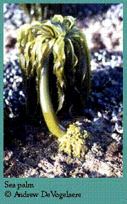 Increasingly, humans visit the rocky shore as naturalists and sightseers, to collect bait and "souvenirs," and to harvest food. Trampling from foot traffic is unavoidable during these activities. At Natural Bridges State Park, in Santa Cruz (Figure 1), an overall pattern of higher diversity and density at less accessible sites was measured by Beauchamp and Gowing (1982). Other more recent studies, have also detected density and species composition changes associated with human use (Duran et al. 1987, Underwood and Kennelly 1990, Kingsford et al. 1991, Addessi 1994). For species with short dispersal distances such as the Sea palm, Postelsia, one 15 minute collecting spree could eliminate the population from a site for the foreseeable future (Dawson and Foster 1982). Harvesting can also impact scientific experiments. In one case near Long Marine Laboratory, dozens of painstakingly marked owl limpets disappeared overnight, when they were apparently collected for a bouillabaisse repast (J. Estes, pers. com.). California Department of Fish and Game provides some control on collecting in the intertidal zone, but innovative measures to minimize trampling impacts will be needed at sites near areas of high human density. The Fitzgerald Marine Reserve is currently experimenting with access/no access areas on rocky benches (T. Niesen, pers. comm.) and quasi trail systems may be appropriate for some areas.
D. Coastal development and road maintenance
Human-made structures to counter coastal erosion can increase and decrease rocky intertidal habitat. In California, roughly 10 % of the coast is structures made by humans (U.S. Army Engineer Division 1971). Rocky habitat has increased in Elkhorn Slough, the largest wetland in the MBNMS, as landowners have armored their shorelines against tidal erosion. Of course, adding rocky shores means an equivalent loss of some other habitat. Especially along the Big Sur coastline, maintenance of the coastal highway creates periodic disturbances that simulate landslides. These events can immediately eliminate rocky shore habitat (Pearse 1984), or have long term impacts related to sand movement and burial on adjacent sites (Bretz and Oliver 1992, Bretz 1995). Studies on the frequency of natural slides versus road-related slides are not available, and the California Coastal Commission permits all coastal development.
E. Water quality
Historically, water quality was a significant issue on MBNMS rocky shores. Primary treated sewage was pumped out on the intertidal shore at Carmel (Mission Point), Point Pinos and Soquel Point until the 1970's (Figure 1). Since then, better sewage treatment and extended sewer lines into the subtidal has eliminated such visibly grotesque impacts such as nearly denuded, diatom and coralline algal-covered rocks, sometimes with toilet paper and other domestic waste products. At Soquel Point, the sewage-enhanced coralline alga assemblage (Doyle and Pearse 1972) still persists, 20 years since the sewage outfall was discontinued, although sea grass beds, more typical of clean water, are slowly returning (Pearse, unpublished data). The State Water Quality Control Board places intertidal mussels throughout California to monitor human health issues, but this program is not used to assess impacts on rocky shore assemblages.
F. Other large scale human impacts
The MBNMS rocky shores have been, and will continue to be used to detect human impacts on a global scale. Barry et al. (1995) detected increasing numbers of warmer water species in Monterey, and concluded that the pattern is consistent with available water temperature data and the hypothesis of global warming. Druehl et al. (1988) were able to detect nuclear fallout from the Chernobyl power plant in Russia by measuring iodine 131 in the intertidal alga, Fucus, some of which were collected from MBNMS shores. Increased and improved monitoring efforts will facilitate future studies on global scales and more local studies on human induced and natural changes.
G. Resource management needs
This section, and interview results provided by the site characterization staff (see Resource Needs section), point to some resource management needs for the MBNMS rocky shores. A comprehensive monitoring program is needed to detect natural and human induced change, as well as in preparation for catastrophic natural resource damage assessment (NRDA). Because of significant between site variability (Foster 1990, Kinnetic Laboratories Inc. 1992) and improved statistical techniques for control/impact studies (Osenberg et al. 1994, Underwood 1994), it is appropriate to have as many monitoring sites as possible, even if the accuracy of rare species assessment suffers. I suggest photoquadrats at many sites, to be analyzed only if the site is impacted or for ancillary studies done by students, combined with detailed sampling at fewer sites to detect trends as they occur. Information from existing long term data sets should be built upon as much as possible (Table 2). Physical parameters and adjacent land use patterns should be measured at the sites as well as biological parameters. Once changes are detected through monitoring, specific experiments would be useful for understanding the cause of the change (MBNMS Research Advisory Committee 1993). Information is clearly lacking on the organization of cracked and cobbled rocky shore assemblages, the impact and possible mitigation techniques for human trampling and use of resources (especially in areas of special biological significance, see Table 2), and understanding weathering processes of hydrocarbons. Finally, a plan should be completed and readily available for NRDA procedures in the event of a catastrophic event.
VII. Acknowledgments
I thank E. Mitchell for obtaining coastline measurements, J. Pearse for information on available long-term data sets, and M. Foster and J. Pearse for reviewing the text.
| < Previous Section V. Links with other Habitats and Assemblages |
||