|
ROCKY SUBTIDAL SYSTEMS |
|||||||||||
|
|
|
While the entire ecosystem monitoring plan will be completed in late 2000, several programs have already begun that will help us achieve our comprehensive monitoring goal. Scientists from several institutions—including the U.S. Geological Survey, MBARI, U.C. Santa Cruz, National Marine Fisheries Service, and California Department of Fish and Game (CDFG)—have made great strides in mapping the Sanctuary's seafloor at various levels, from the shallow nearshore to Monterey Canyon and the abyssal plains. Beginning in 1999 investigators from C.S.U. Monterey Bay and Moss Landing Marine Laboratories are tying these mapping projects together and coordinating the creation of a comprehensive marine habitat GIS (geographic information system) for the California continental shelf. Their general approach is to compile, digitize, update, reinterpret, and verify existing data as well as to initiate the effort to fill the most critical data gaps within existing habitat data coverage for nearshore marine habitats. This project is building upon the collaborative work already begun by the CDFG GIS staff in developing a nearshore ecosystem database. In addition to answering several basic scientific questions, a main priority is to make use of all existing data and technologies to define and map essential marine habitats on the continental shelf and to make these data available in digital formats accessible to, and usable by, local, state, and federal resource agencies. This year the Sanctuary's research staff has also begun mapping and monitoring a critical Sanctuary resource—kelp communities. Forests of giant kelp (Macrocystis pyrifera) and bull kelp (Nereocystis leutkeana) characterize much of California's nearshore environment. These rich communities have vast ecological, economic, and aesthetic value, and thus their current and future conditions are a great concern. To understand both natural and human impacts on the temporal and spatial dynamics of kelp forests better, we have begun a long-term kelp canopy monitoring program. Building on previous work, the Sanctuary began flying aerial kelp canopy mapping surveys (see below) in the early fall of 1999. With the return of cooler waters during the recent La Niña conditions, we found tremendous kelp growth. Canopy cover in the Sanctuary and all along the West Coast during the fall of 1999 was at its highest level in more than twenty years. The various studies described above complement other research efforts detailed in this report, such as those focusing on beaches and rocky shores. Additionally, surveys of vessel traffic, marine reserves, and water quality will all contribute to the Sanctuary's comprehensive ecosystem monitoring efforts. --Mario Tamburri, Research Fellow Sanctuary-Specific
Kelp Plan In the summer of 2000 the California
Department of Fish and Game (CDFG) will
once again prepare a California Kelp
Management Plan for the California Fish
and Game Commission (FGC). This Plan will
govern the harvest of kelp in California
until 2005. The CDFG will review the
current California Kelp Management Plan in
late spring and make appropriate revisions
for the FGC to review in the summer of
2000. Parallel to the state's process
described above, the Monterey Bay National
Marine Sanctuary is developing a
"Sanctuary-Specific Kelp Plan" focusing on
kelp issues within its boundaries. The
purpose will be to make appropriate
recommendations to the CDFG and FGC
regarding Sanctuary waters, for
incorporation into the State Kelp
Management Plan. The first of two public
drafts—Background and Environ-mental
Setting—was released in January 2000.
After receiving public comments, the
Sanctuary staff planned to prepare a set
of recommended actions, to be released
later in 2000 for public comment.
Sanctuary staff anticipate releasing the
Final Plan in May 2000; it will contain
the Sanctuary's recommendations to the
CDFG and FGC. The Sanctuary will develop
its report and recommendations through an
open public process that includes the
Sanctuary Advisory Council, its working
groups and subcommittees, and other public
and private organizations. The issue of the appropriate level of
kelp harvest is an ongoing one within the
Sanctuary, particularly due to recent
plans approved by the California Coastal
Com-mission to develop new abalone farms
in the region. The Sanctuary, including
its Advisory Council, acknowledges that
there are many legitimate "uses" of kelp,
including harvesting, recreational uses
such as kayaking and SCUBA diving,
research, and inherent biological benefit
to organisms. The Sanctuary retains authority to
regulate kelp harvesting, but recognizes
the historical authority of California in
managing that issue, and prefers to work
through that authority rather than issue
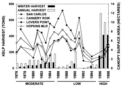
its own regulations. --Aaron King --John Muhilly Researchers from Moss Landing Marine Laboratories investigated this question using aerial photographs taken since 1976 and available kelp harvest records from the California Department of Fish and Game (Figure 1). These data were analyzed with a modified Before-After-Control-Impact study design, currently one of the most statistically rigorous tests to detect environmental impacts. The abundance of kelp canopies, as measured by the surface area of floating canopy during the fall period of maximum canopy development, was compared among three harvested sites (San Carlos, Cannery Row, and Lovers Point) and an un-harvested control site (Hopkins Marine Life Refuge; HMLR) both before and after harvesting began. There was no detectable effect of current kelp harvesting practices on kelp canopy abundance, but statistical power to detect an effect was low given the small sample size of the "high harvest" period (n = 2) and high natural variability of kelp canopies. Therefore, these results do not necessarily indicate that there was not a harvesting effect, only that such an effect was undetectable given the available data. Increasing sample size (i.e., more yearly aerial kelp canopy surveys in the future) is the only way to refine these results further. Interestingly, we did detect a statistically significant decline in kelp canopy during the 1970s and 1980s at San Carlos, presumably due to the harvesting activities of the now-defunct Monterey Abalone Farm that operated on Cannery Row. However, this result was probably confounded by short-term harvesting effects (i.e., canopy removal immediately prior to aerial surveys), which precluded meaningful interpretation and comparison with current harvesting practices. This review and analysis outlined a procedural groundwork for future investigation of kelp harvesting and highlighted the value of establishing and using long-term data sets of kelp canopy surveys for assessment of environmental impacts in the nearshore marine ecosystem. --Michael D. Donnellan and
Michael S. Foster
Local
High School Students Study Marine
Protected Areas In 1999 a SCUBA/marine research team of
eighteen students from four area high
schools (Carmel, Pacific Grove, Aptos, and
MAOS at Monterey) began collecting data
inside and adjacent to Point Lobos Marine
Reserve—one of three designated
"no-take" Marine Protected Areas (MPA)
located within the Monterey Bay National
Marine Sanctuary. The project is
contributing to ongoing research to
determine the effectiveness of such
"no-take zones" in replenishing commercial
fishing stocks while also providing a
wonderful educational experience for
participants. In preparation, students became
certified as open water SCUBA divers,
learned about resource management within
the Sanctuary, became familiar with marine
research techniques, and learned to
identify ninety-seven species of marine
invertebrates and sixty-three fishes
indigenous to the Carmel Bay area. The
students completed more than 200 research
dives inside the reserve and on the
adjacent reef at South Monastery. Students
swam "fish transects" in order to count
the number and variety of twelve "target"
resident fish species and recorded whether
the fish were juveniles or adults. The
students also completed a "site
characterization" that describes the
depth, substrate, algal species,
temperature, currents, and visibility
extant in their study sites. In addition,
they used a 25 by .25 meter quadrat to
count the absolute numbers of twenty
species of sessile invertebrates on the
rocky reef. They established a database to
describe the reef within the reserve
accurately and compared it to another
immediately outside of the protected area.
In this way they controlled the variables
before determining whether these two reefs
are similar enough to support the
comparable populations of fishes.
Statistical analysis of the transects,
quadrats, and video footage allowed
students to compare the results of
research conducted inside and outside the
reserve. A preliminary analysis of our data
indicates that there are more mature fish
inside the reserve while there are more
juvenile fish outside (at South
Monastery). With virtually no mature fish
outside the reserve these juvenile fish
most likely are the product of recruitment
from the adjacent MPA. The biggest
question that remains to be answered is
what proportion of a fishery needs to be
set aside as an MPA for this to be an
effective method of resource
management. Note: for additional information on
research into marine protected areas,
please see Ecosystem Observations 1998,
Pages 7-8) |
|||||||||
|
|
|
Home | Introduction | Visitors | Education | Research | Protection | Calendar | Foundation | Search
Credits
For comments or question please refer to the Webmaster
Last modified on: March 31,
2000