Water Quality Protection Program Overview
The Monterey Bay National Marine Sanctuary (MBNMS) encompasses a shoreline length of 276 miles from Marin County in the north to San Luis Obispo County in the south and 6,094 square statute miles (4,601 nmi2) of ocean. This proximity to the coastline makes the Sanctuary vulnerable to pollution problems from approximately 7,000 square miles within watershed areas that drain to it, including contaminants such as sediments, nutrients, fecal bacteria, pesticides, oil, grease, metals, and detergents.
Recognizing that water quality is key to ensuring protection for all Sanctuary resources, a Memorandum of Agreement was signed in 1992 and updated in 2006 by eight federal, state and local agencies agreeing to work together to develop a Water Quality Protection Program (WQPP) for the Sanctuary. Today the WQPP Committee is dedicated to protecting and enhancing water quality in the Sanctuary and its watersheds. Using a collaborative approach involving key stakeholders in each issue, detailed plans have been completed:
|
|
|||||||||||||||||||||||||||||||||

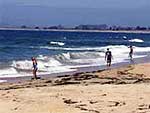 Beach Closure and Microbial Contamination
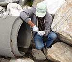
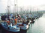 Marinas and Boating
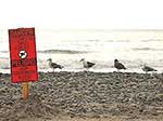 Regional
Monitoring
Regional
Monitoring
Public outreach and education is a key factor in the success of the WQPP. Various water quality education materials and programs have been developed, including posters, brochures, watershed models and displays.