Resource Issues: Lost Fishing Gear Project
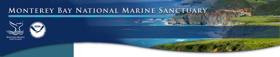
 Crab trap removed from MBNMS (Oct.22, 2009) Crab trap removed from MBNMS (Oct.22, 2009) |
Overview of the Issue
Lost fishing gear is identified as fishing nets, lines, pots, traps, and other commercial and recreational fishing gear that sits on the seafloor, gets caught on rocky reefs, or floats in the water column. Lost fishing gear is a concern for the following reasons:
- Gear can create long-term entrapment mechanisms that continuously impact fish and crustaceans for many years. Net materials are constructed to be strong and resilient, thus preventing escape of entangled wildlife and persisting in the environment for decades.
- Nets and traps have also been documented to entangle bottom feeding whales and other marine mammals, becoming ensnared on flukes and fins.
- Lost fishing gear can cause hazards to fishing gear being actively used by fishermen. For example, lost traps may snag additional traps being set nearby. Catching new gear on lost gear is a nuisance and a hazard.
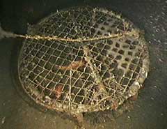
 Remotely operated vehicle (ROV) Phantom HD2 Remotely operated vehicle (ROV) Phantom HD2 |
How is the Sanctuary involved?
From 2009 to 2011, Monterey Bay National Marine Sanctuary (MBNMS) and partners (see list below) implemented a project to document and remove lost fishing gear from the deepwater habitats of the sanctuary using a remotely operated vehicle (ROV), the Phantom HD2.
The primary results of the Lost Fishing Gear Removal Program were:
- Documentation of the abundance and types of gear in water up to 1000 ft in the MBNMS
- A GIS database was developed integrating data from Delta Submarine dives conducted by staff from the National Marine Fisheries Service, from camera sled and ROV dives by CSUMB, from ROV work by DFG and from locations of gear found during this study.
-
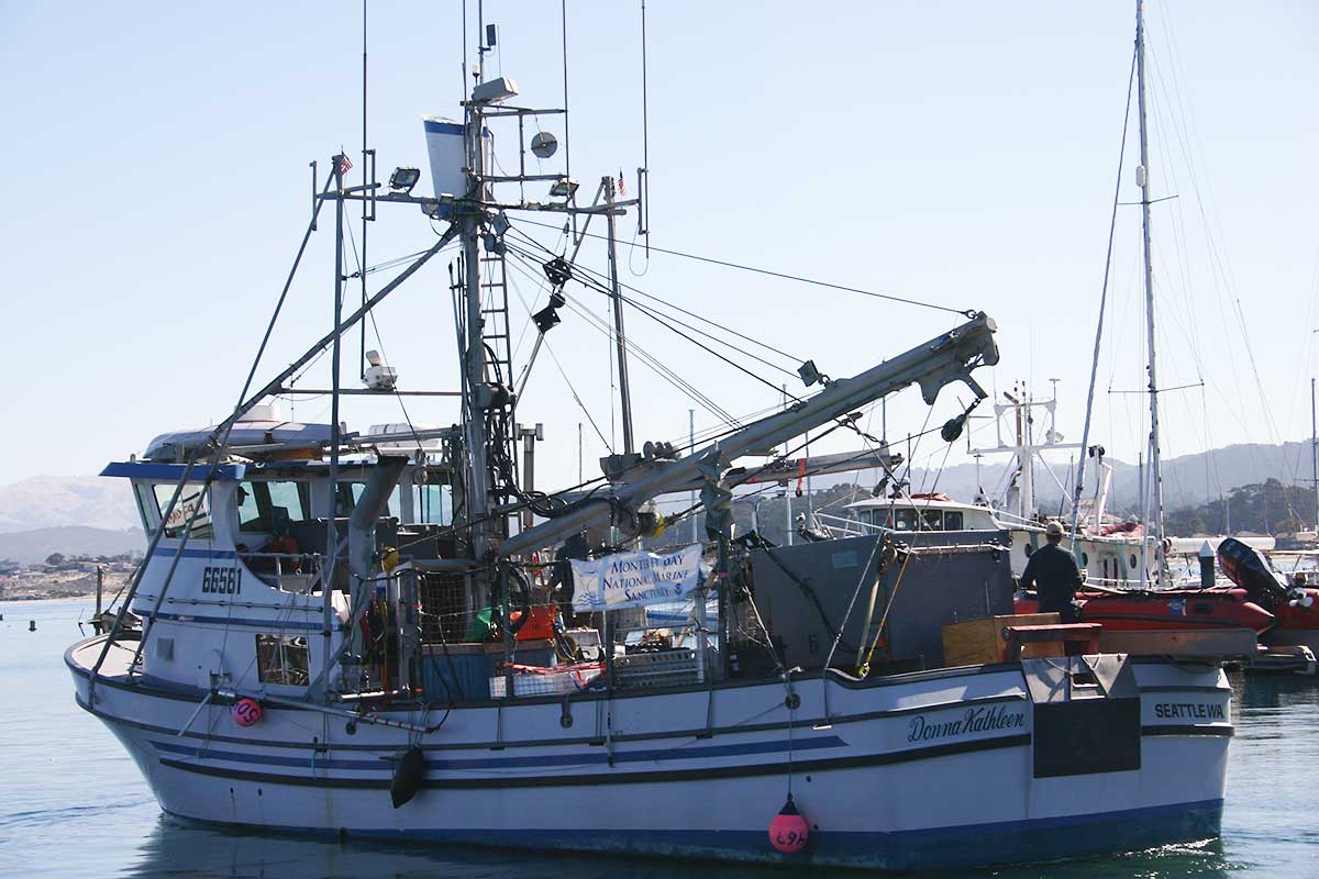
Refinement of deepwater remotely operating vehicle (ROV) retrieval procedures (See Lost Fishing Gear reports)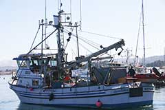 The fishing vessel Donna Kathleen made an excellent platform for the Lost Fishing Gear Removal Cruises in 2009 and 2010. Captain Tim Maricich and his son Tyler and wife Donna were an ideal crew for this particular project due to their knowledge and understanding of fishing gear as well as the local sites.
 - Reduction of impacts to the sanctuary such as ghost fishing & navigational hazards
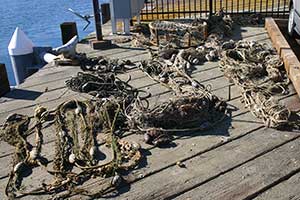
- Retrieved gear included over 1000 ft of rockfish gillnet, a variety of crab and spot prawn traps and 700 lbs of clump weight lead.
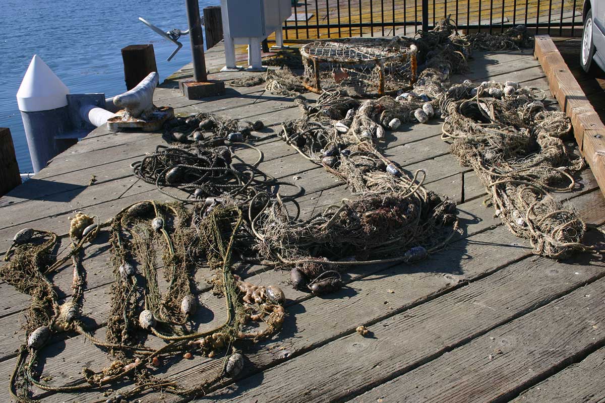
 Recovered fishing gear
- Retrieved gear included over 1000 ft of rockfish gillnet, a variety of crab and spot prawn traps and 700 lbs of clump weight lead.
- Completed site surveys and video characterization of a variety of habitats
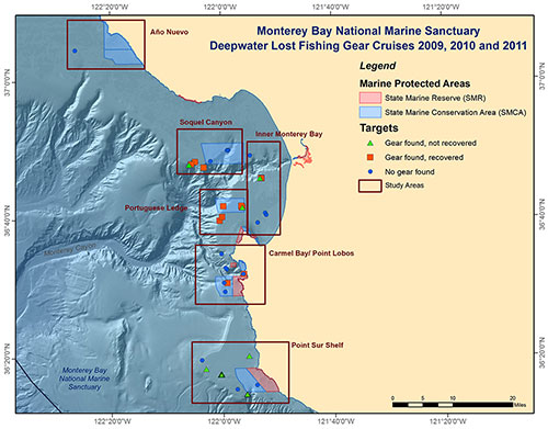
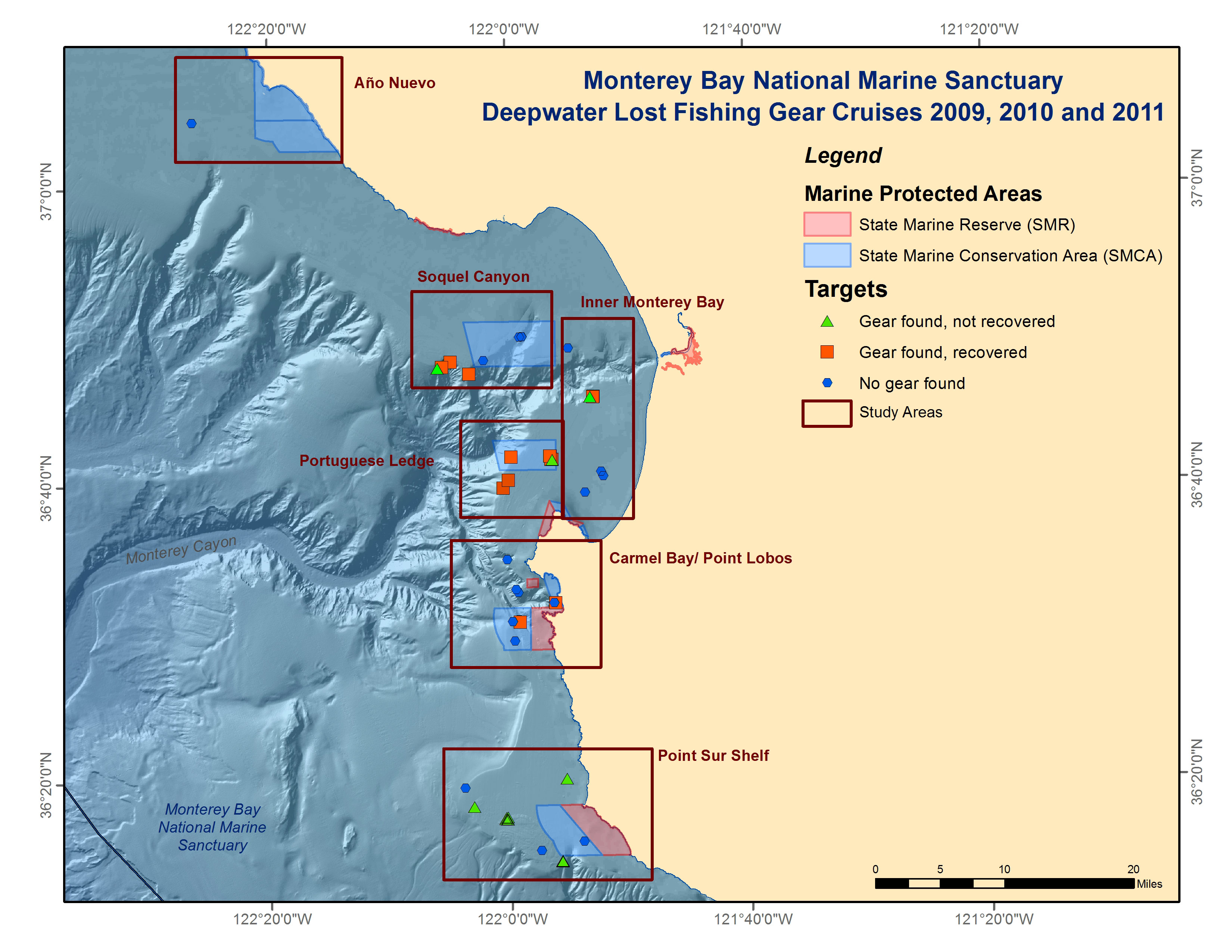
This map shows the location of targets of lost fishing gear, including nets and traps, identified from previous ROV or submersible surveys. Gear was recovered when feasible (orange squares) or otherwise entered into the database (green triangles). Surveys of areas where no gear was found are indicated as blue hexagons. - Outreach products from the project include:
- Mission logs and pictures on Facebook
- Articles and TV segments
- Monterey Bay fishing boat searching for an unusual catch: old fishing gear. Silicon Valley Mercury News. 10/31/11.
- Press Release: NOAA Removes Lost Fishing Gear in Monterey Bay National Marine Sanctuary: Underwater robot deployed during three-year project (46K PDF)
-
Specialized GIS tool Eonfusion visualization project with CSUMB showcased in a video. Caption “A brief introduction of the Deepwater Lost Fishing Gear Recovery project led by MBNMS. Here we showcase some specialized GIS tools that were used to analyze the density of the lost fishing gear that we found using an ROV." -
Video of net recovery. Caption “A rockfish gill net is removed from 300 meters depth in Soquel Canyon SMCA using an ROV, a boat winch, and good, old fashioned elbow grease! “
Specimen Collections
This project provided a unique opportunity to characterize encrusting invertebrate communities associated with lost fishing gear. In state marine protected areas, invertebrates were removed by hand when possible, photographed on deck, and then returned to the water, as well as any entrapped fish. At locations outside state MPAs, unusual or interesting specimens found on the nets or in traps were collected for educational or scientific purposes. Selected invertebrates associated with the retrieved gear were collected and/or photographed. As lost fishing gear tends to create artificial habitat for encrusting organisms, Steinhart Aquarium took and exhibited one of the retrieved spot prawn traps in their Monterey Bay tank. Cal Academy provided a species list for all collected specimens which included sponges, worms, mollusks and brachiopods (see reports for a complete list).
Funding and Partners
This project is partially funded by the "Restoration Plan for the M/V Med Taipei ISO Container Discharge Incident Fund." This is one of six restoration activities that are currently being implemented as part of the natural resource settlement plan. The loss of 15 intermodal cargo containers resulted in direct habitat impact and the projects will compensate for their continued presence and impact on the seafloor within the sanctuary. Additional funding is through a marine debris grant awarded to the UC Davis SeaDoc Society by the California Wildlife Conservation Board. Other key contributors to this effort include the California Department of Fish and Game, California State University Monterey Bay (CSUMB), Cordell Bank National Marine Sanctuary (CBNMS), the F/V Donna Kathleen, Marine Applied Research and Exploration (MARe), Monterey Peninsula College's MATE program, the National Marine Fisheries Service (NMFS), and Cal Academy.
More Information
- "Retrieving Lost Fishing Gear from Deepwater Habitat Project Poster" (1.5M PDF)
This poster will be presented at the 2014 Sanctuary Currents Symposium and highlights the Lost Fishing Gear Project activities from 2009 to 2011. - "Sixty Tons in Six Years: Reducing Threats to California Marine Wildlife Through Lost Fishing Gear Recovery" (25K PDF)
This abstract highlights the effort and succes of six years of recovery and removal of lost or derelict fishing gear and debris from the California coastal waters. Written and provided by from The SeaDoc Society at UC Davis Wildlife Health Center. - 2009 Lost Gear Project Cruise Report (698K PDF)
During the 2009 Lost Fishing Gear removal cruise we focused 22 ROV dives over 8 days on Portuguese Ledge and Cypress Point. Total gear removed during this cruise totaled 500 pounds of crab pots and legacy gear. - 2010 Lost Gear Project Cruise Report (800K PDF)
During the 2010 Lost Fishing Gear removal cruise, dives were conducted in five main study areas which included the edges of Monterey Canyon, the edge of Soquel Canyon, Ano Nuevo, Carmel Bay and Point Lobos. We retrieved 450 feet of rockfish gillnet, two crab pots, a spot prawn trap and 600 pounds of lead weights. We also completed HD video surveys, including those of a large intact trawl net and a 50-foot sunken sailboat. - 2011 Lost Gear Project Cruise Report (5.4M PDF)
MBNMS staff and partners conducted a ten-day research mission in 2011 to survey deepwater habitats, including at Point Sur, and to remove lost fishing gear, such as traps and nets, from the seafloor using an ROV. Recovered gear was either lightly or heavily encrusted, yet did not appear to be actively fishing. - Med Taipei
Restoration Plan for the M/V Med Taipei ISO Container Discharge Incident.