PART
II: THE AFFECTED ENVIRONMENT
II. Section: Sanctuary Resources
II. Section: Sanctuary Resources [Part II TOC]
A. Introduction [Part II TOC]
The unique marine resources of Monterey Bay are attributable to the area's large submarine canyon and a special set of oceanic conditions that combine to produce the bay's highly productive waters. Distinct bathymetry, combined with the area's ocean currents and thermal structure, produce strong seasonal upwelling of nutrient- rich deep water. These highly productive nearshore waters in turn support diverse floral and faunal populations. The extensive kelp beds, and the diversity of rock types, sediment types, and shoreline characteristics combine with the nutrient-rich waters to form several habitat assemblages.
Monterey Bay has the most varied algal community in North America. The area supports a large, diverse population of marine mammals, including the endangered California gray whale, finback whale, humpback whale, sperm whale, and California sea otter. Año Nuevo, at the northern end of the proposed Sanctuary area, is the most important pinniped rookery and resting area in central and northern California. The bay area is important as a staging habitat for avifauna along the Pacific Flyway. The waters support extensive and varied fish populations.
B. Environmental Conditions [Part II TOC]
1. Geological Oceanography [Part II TOC]
The Monterey Bay region is located on the continental margin within the California Coast Ranges province. It is situated on a major structural unit of the earth's continental crust called the Salinian Block. Approximately 20 million years ago, this block was displaced northward from the southern Sierra-Nevada Mountain Range on the Pacific tectonic plate by movement along the San Andreas Fault. Faults in the Monterey Bay area lie primarily within two major, essentially northwest-southeast-trending fault zones: the Palo Colorado-San Gregorio and the Monterey Bay fault zones (H. G. Green, pers. comm., 1989). The Monterey Bay Fault Zone is located in Monterey Bay between Monterey and Santa Cruz. It forms a diffuse zone, 10 to 15 km wide, of short en echelon, northwest-trending faults (Green, 1977). The Palo Colorado-San Gregario fault system is formed by the San Gregario fault which extends from Point Año Nuevo to Point Sur where it connects with either the Palo Colorado fault (Dohrenwend, 1971; Green, 1977) or the San Simeon fault. Movement in the active San Andreas Fault caused the October 17, 1989 Loma Prieta earthquake; the epicenter of the magnitude 7.1 earthquake was located near Santa Cruz.
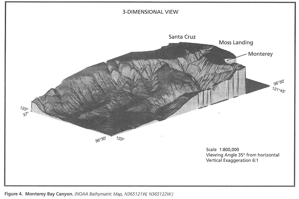
The most prominent geological feature of Monterey Bay is the Monterey Submarine Canyon (Figure 4). The main canyon begins in 18 m of water about 100 m offshore from Moss Landing. There are two main branches of the Monterey Canyon: Soquel Canyon to the north and Carmel Canyon to the south. An additional canyon - Ascension Canyon - indents the shelf off of Año Nuevo. The entire canyon extends about 45 nmi (82 km) offshore to the foot of the continental slope at a depth of about 2925 m. At about 1830 m depth, the height of the canyon walls attains proportions similar to that of the Grand Canyon of the Colorado River (Shepard and Dill, 1966). Today, Monterey Canyon is actively being excavated and exhumed. This activity continues to be tectonically controlled as fault rupture, brought about by plate motion, causes earthquakes that stimulate slumping and turbidity flows within the canyon. Continued movement along strike- slip faults is also displacing a segment of the deeper part of the canyon to the north (Green, in press).
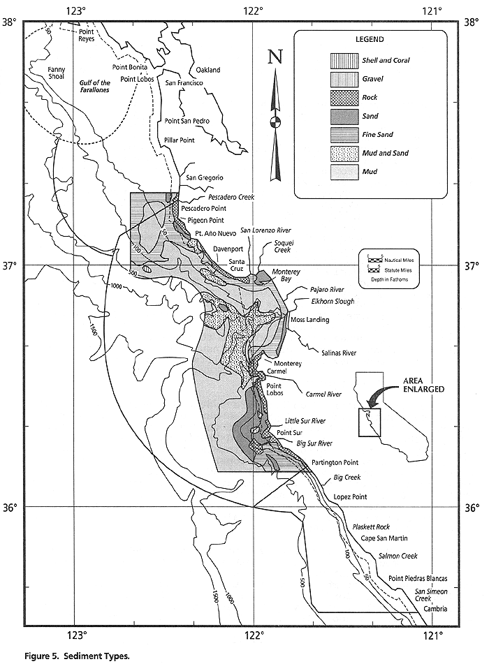
The substrate of the region is variable (Martin and Emery, 1967). The surface sediment types tend to follow the seafloor contours (Figure 5). Nearshore, the sediments are sand and fine sand and offshore they are sand and mud. In both areas, the sediments overlie beds of sandstone, siltstone, and conglomerate. From the mid to late Miocene (approximately 15 million years ago), sediments were deposited in the Monterey Bay area. Over time they created the marine shale that is currently considered to be of primary hydrocarbon potential, specifically in the Año Nuevo and La Honda Basins. The sediments in the canyon vary from sand nearshore to mud in the deeper areas. Rocky outcrops are found on the walls Figure 4: Bathymetric Map of the canyon. About 3.2 million cubic yards of sediment are deposited in the bay during the winter and spring months by the San Lorenzo River, Soquel Creek, Aptos Creek, Pajaro River, and the Salinas River (Griggs, 1986).
The Monterey Bay area is characterized by a narrow continental shelf and is surrounded by a variety of coastal types. The San Mateo coastline to the north of Monterey Bay consists of long stretches of sandstone cliffs with intermittent breaks created by streams that provide sandy beaches and small estuarine habitats. The cold ocean currents, coastal fog, tectonic upthrust, and sandstone cliffs provide an ideal environment for the creation of intricate caves, caverns and underground labyrinths known as "tafoni". These dramatic and complex erosional features are especially intricate in the Cretaceous sandstone of the Pigeon Point formation on the San Mateo Coast.
The northern coastline of Monterey Bay has sand bluffs and flat- topped terraces of mudstone as well as rocky intertidal areas. From Soquel Point southward to Moss Landing, cliffs fronted by sandy beaches predominate. Sedimentary rocks, mostly shales, form the slopes of the Salinas Valley and the flat coastal shelf at the north end of the bay (Gordon, 1977). The rough, boulder-strewn headlands of Point Pinos at the southern part of the bay are composed of granite. The white dunes and beaches of Pacific Grove are derived from the weathering of these granites. Sandy beaches backed by large dunes extend southward to the rocky headland of the Monterey Peninsula. South of the Peninsula is the Big Sur coast-line that is renowned for its steep cliffs and rocky headlands.
2. Meteorology [Part II TOC]
The North Pacific High Pressure System dominates the region's large-scale meteorology, and produces northerly winds along the entire U.S. west coast during most of the year (Beardsley et al., 1987). The System migrates northward and intensifies during early spring, providing the strong upwelling-favorable coastal winds characteristic of March through October (Nelson, 1977). The direction and intensity of coastal winds are also strongly influenced by local coastline orientation and topography (Zemba and Friehe, 1987). Large-scale fluctuations in the wind are caused primarily by atmospheric storm systems that are several hundred miles in diameter, and have time scales longer than about two days (Halliwell and Allen, 1987).
In the Monterey Bay area seasons are weakly developed. The area has a moderate maritime climate with the general pattern of wet winters and relatively dry summers. January and February are usually the wettest months, while July and August are virtually without rainfall (Gordon, 1977). The amount of rainfall varies markedly not only year to year but also on both sides of the bay. Monterey averages about 15 inches (38 cm) annually; Santa Cruz averages about 28 inches (69 cm). During the period of March through October the prevailing winds are from the northwest (Nelson, 1977). Winter winds are variable, often from the west or southwest. Winds are strongest in May (averaging 14 knots) and weakest between November and January (averaging 3 knots) (Breaker and Broenkow, 1989). The cool water of the California Current flows south along the coast during March through October; however, between November and February, this current moves offshore off the continental shelf and slope and is replaced with the warmer, northward flowing waters of the Davidson Current (See the Physical Oceanography section for more detail on current movements in the area). The net effect of these alternating currents is that the Monterey Bay climate is characterized by both northern temperate and southern sub-tropical features.
Air temperatures along the shoreline can vary significantly depending upon protection from the dominant northwest winds and storms. For example, Año Nuevo has a distinct microclimate making it warmer, and with more sunshine and fog-free days than coastal areas directly to the north or south (Weber, 1981). Both annual and diurnal temperature ranges are small because of the moderating influence of the ocean. The central California coast is characterized by a recurrent fog during spring and summer. Heavy fog predominates in the morning near the coast with clearing usually occurring with the afternoon's warmer temperature. The fog is caused when the warm moist air associated with the prevailing westerly winds comes in contact with the cold upwelled waters along the coast.
3. Physical Oceanography [Part II TOC]
a. Waves [Part II TOC]
The height and period of waves in Monterey Bay and the nearby coastal ocean vary with the seasons and location. Heights are greatest during winter and lowest in summer (Seymour et al., 1990). Under the more stable summer conditions, the waves are able to build broad, gently-sloping beaches. Winter conditions produce higher waves that transport sand to the offshore zone and erode beaches (Gordon, 1977).
The typical significant wave height at Marina is about 75 cm with a period of around 7 seconds. Severe waves occurred in the mid- 1980's that inflicted damage to the Monterey Regional Water Pollution Control Agency (MRWPCA) outfall. The bathymetry of the Bay, particularly with the submarine canyon has the ability to refract longer period waves, causing a diverging, or lessening of wave energy near the head of the submarine canyon. However, this is done at the expense of wave energy converging to the south and north which may have caused the damage to the MRWPCA outfall.
The northern Bay is somewhat protected from the most energetic storms from the northeast. The significant wave height in Santa Cruz Harbor is about 60 cm, which is concentrated as longer period swell. Wave periods outside the Bay are similar to those at Marina. However, waves at locations away from the coast are usually larger. Maximum daily significant wave heights in exposed areas of the Bay are generally 2-4 m. Heights of about 1 m are typical off Half Moon Bay, significant wave heights of 2 m and greater occur regularly in the Gulf of the Farallones. Swells of 3-4 m and greater have been measured at offshore locations at all times of the year.
Because it is a semi-enclosed basin, the surface of Monterey Bay will also seiche, or fluctuate, at several longer periods (up to 36 minutes) that are characteristic of its geometry (Schwing et al., 1990b). Seiching generally develops following strong winds, or seismic activity. Given its position relative to several active fault zones, it is not surprising that tsunamis, or seismic sea waves, as large as 1.5 m have been observed in the Bay (Lander and Lockridge, 1989; Schwing et al., 1990b).
b. Water Temperature [Part II TOC]
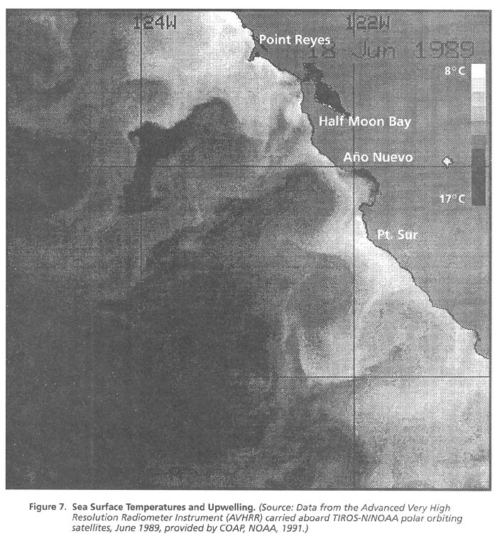
Water temperatures in the bay appear to be largely controlled by the oceanographic conditions off the coast. Surface water temperatures average 52oF (11oC) to 54oF (12oC) during late fall and early summer. No distinct thermocline is present during this period. Surface temperatures in the summer reach 59oF (15oC) and higher (Harville, 1971). Infrared satellite images taken during spring and summer often show cold upwelled water across the entrance of Monterey Bay. However, in a narrow nearshore band along the eastern edge of the Bay, sea-surface temperatures are much warmer than elsewhere, reflecting the importance of local heating within the Bay (Breaker and Broenkow, 1989). (See section on Upwelling and Eddies). More recent data (Tracy, 1990; Farrel at al., 1990) indicate that warmer, fresher oceanic water moves rapidly into the Bay during periods of weak or southerly spring and summer winds. Thermal gradients, both vertically and horizontally, are greatly reduced in winter.
c. Offshore Ocean Currents [Part II TOC]
The California Current System (CCS) is a part of the great clockwise circulation of the North Pacific Ocean (Dodimead et al., 1963). At high latitudes, water moves eastward under the influence of strong westerly winds. Near the coast of North America, the flow divides into two branches. The smaller component turns northward into the Gulf of Alaska; the larger component turns south-eastward to become the California Current (Figure 6).
The California Current transports Subarctic water of relatively low temperature and salinity, and high dissolved oxygen and nutrients toward the tropics (Hickey, 1979). As it moves
south, much warmer and saltier Subtropical water, featuring low oxygen and nutrient concentrations, gradually mixes in from the west. Water temperatures at the surface range between 52šF (11šC) and 55šF (13šC). Equatorial Pacific water which is warmer, saltier, lower in oxygen and higher in nutrients than surrounding waters, mixes in at subsurface levels as this current flows north. The California Current is also diluted by precipitation and coastal runoff, primarily from the Columbia River. The core of the California Current off Point Sur lies about 60-125 miles (100-200 km) from the coast and features maximum equator-ward velocities of less than 5-10 cm/s (Chelton, 1984). The offshore portion of southward flow is seen up to 600 miles (1000 km) offshore and extends deeper than 500 m, but the inshore section of the Current is limited to the upper 200 m over the continental slope (Hickey, 1979). Two velocity maxima per year are noted, in February-March and again in July-August (Chelton, 1984).
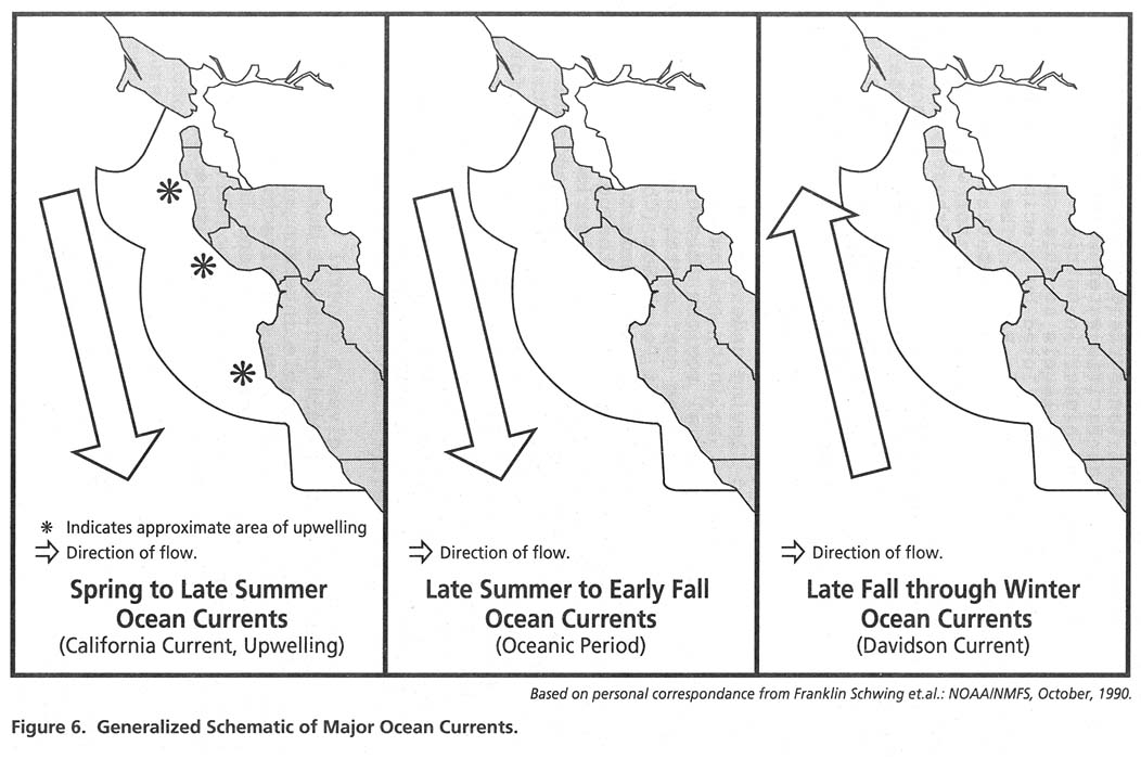
The CCS includes two other primary currents off central California; the California Undercurrent and the Davidson Current (Figure 6). The northward flowing undercurrent transports water of relatively high temperature, salinity and nutrients and low dissolved oxygen from equatorial regions (Hickey, 1979). The undercurrent is trapped along the continental slope, within 45-60 miles (75-100 km) of the coast off Point Sur (Chelton, 1984) at depths of over 200 m. Northward flow extends to the surface from October through February; this portion of the poleward flow is referred to as the Davidson Current. Once it rises to the surface, it forms a wedge between the California Current and the coast. Its rate of flow is less than one knot. Upwelling stops during this period but returns in March with the return of the California Current. A second, weaker period of northward surface current is noted in late summer over the slope off San Francisco and Monterey. These northward periods of surface flow coincide with the core of the California Current moving offshore (Lynn and Simpson, 1987). The Undercurrent is weakest in spring and early summer. Velocities of up to 14 cm/s occur near the surface in December.
While this description gives a general view of the large-scale current patterns off central California, it must be stressed that this mean flow exhibits considerable interannual variability. Much larger variations in flow, intensity and direction that occur throughout the year at periods of 10 days and less are superimposed on seasonal patterns (Chelton et al., 1988). In addition, the character of the CCS varies greatly with latitude (Hickey, 1979).
d. Upwelling and Eddies [Part II TOC]
Jets, eddies and meanders all contribute to water mass mixing, and make the flow of the CCS extremely complex. Highly transient coastal jets, or filaments, have typical surface currents of 50 cm/s, and are usually 12-30 miles (20-50 km) wide and 100-200 m deep (Brink, 1987). Eddies, some as large as 60 miles (100 km) in diameter, are able to transport seawater transverse to the mean flow; i.e., normal to the coast (Traganza et al., 1981, Tracy, 1990). Filaments of cold water may be carried more than 100 miles (160 km) offshore from upwelling centers off Point Sur (Breaker and Mooers, 1986) and Año Nuevo (Tracy, 1990). These filaments frequently display a high concentration of plant pigment, indicating high productivity (Simpson et al., 1986).
Evidence suggests the cool nutrient-rich surface waters found in Monterey Bay are advected from sources outside the Bay (Figure 7). The area near Año Nuevo has clearly been identified as one source of this water (Tracy, 1990). Southward flow across the mouth of the Bay is indicated by sequences of satellite imagery over several consecutive days (Tracy, 1990), although no accurate estimates of current speed can be made at this time. As it flows south, some of this upwelled water makes its way into the Bay. When it is present, a front observed across the mouth of the Bay may inhibit exchange between the Bay and ocean (Breaker and Broenkow 1989; Tracy 1990).
When northerly winds relax, a warm clockwise-rotating eddy moves shoreward, bringing oceanic water into the Bay (Bolin and Abbott, 1963; Breaker and Broenkow, 1989; Farrell et al., 1990; Tracy, 1990). Water upwelled off Point Sur may flow northward into the Bay on occasion. Satellite imagery also shows upwelling off of Pillar Point with filaments of cold water extending south towards Monterey Bay (Figure 6). This period of upwelling occurs almost continuously between March and October. After upwelling stops, there is a short period when the California Current is still the dominant current pattern but water conditions change slightly. This so-called oceanic period is marked by the absence of upwelling and a warming of the surface water temperature to more than 55šF (13šC). As the surface waters are moved offshore and replaced by the cold, nutrient-rich waters from below the resultant upwelling introduces the nitrates, phosphates, and silicates that are essential for high phytoplankton production in the surface waters. These events are responsible for the highly productive waters of Monterey Bay.
Ekman pumping due to local spatial variations in wind stress (Breaker and Broenkow, 1989) and up-canyon flow (Bigelow and Leslie, 1930; Breaker and Breaker and Broenkow, 1989) have been proposed as mechanisms for local upwelling within Monterey Bay, but there is no hard evidence to support these theories at this time. Long-term satellite observations of surface temperature have not displayed localized upwelling centers inside of the Bay (Tracy, 1990) (Figure 7). Large internal waves of tidal frequency, observed near the end of the Canyon (Shea and Broenkow, 1982), may move deeper waters up onto the shelf in that area.
e. Nearshore coastal currents [Part II TOC]
In addition to being influenced by the CCS, currents near the coast are affected by a variety of forces and boundary conditions, including local winds, upwelling, lateral and vertical mixing, tides, freshwater inflow, solar heating, bathymetric changes and El Niño episodes. Coastal currents are separate from the large-scale CCS flow and are primarily forced by local winds.
While Monterey Bay is unlikely to be impacted directly by variations in the CCS, its indirect effects will be felt through changes in coastal ocean conditions adjacent to the Bay. Coastal flow is much more transient and variable than that seen in the CCS, primarily because atmospheric variations produce a much stronger and more rapid ocean response in shallow water. Current meter studies between the Farallones and Monterey Bay have measured flow predominantly alongshore to the south during the upwelling season (February-September) due to the prevailing northerly winds (Strub et al., 1987; Chelton et al., 1988). Typical current speeds are 20-30 cm/s alongshore and 5-10 cm/s onshore. Ship surveys and satellite imagery off central California reveal that water clearly travels large distances south during this time of year (Robson, 1990; Schwing et al., 1990a, Tracy, 1990). A net northward flow has been observed during the rest of the year (Strub et al., 1987). However, this seasonal cycle is of very small amplitude; alongshore velocities of 10-20 cm/s in either direction occur throughout the year in response to changes in wind direction (Chelton et al., 1987).
South of Monterey Bay, currents are typically northward in all months except March-May, with an offshore surface flow and an onshore component at depth (Strub et al., 1987; Chelton et al, 1988). Coastal currents adjacent to the Bay not only vary in direction seasonally, and in response to changes in wind speed and direction over periods of 10 days and less, but can simultaneously flow in opposite directions at two nearby locations. Thus the coastal ocean near Monterey Bay is a zone where currents frequently converge from the north and the south. Currents in the Farallones as little as 9 miles (15 km) apart display very different cross-shelf patterns (Noble and Gelfenbaum, 1990). The flow field is also difficult to predict with any certainty; only about 50% of the variations in current can be attributed to the wind (Chelton et al., 1987; Noble and Gelfenbaum, 1990).
Few direct current measurements have been made within Monterey Bay, and most of those were very near shore (current meters) or of short duration (drogues). These limited measurements (ESI, 1978; Ecomar, 1981, cited in Breaker and Broenkow, 1989) indicate predominantly northward flow in a narrow nearshore band along the eastern edge of the Bay. The distribution of barnacle larvae is consistent with this pattern (K. Miller, pers. comm., 1990). The results of non-concurrent short duration current meter measurements in the Canyon (Shephard et al., 1979, and see Breaker and Broenkow, 1989) are inconclusive. The flow within and through the Canyon, and the effects of the Canyon on shelf currents are unknown.
Most of what is known about flow in the Bay has been inferred from indirect evidence such as plankton and nutrient distributions, and in situ and remote temperature measurements (Broenkow and Smethie, 1978). Due to the large changes in the Bay's water structure that may take place over very short time periods (about one day during the upwelling season), currents inferred from shipboard surveys, may not be reliable. On the other hand, flow inferred from snapshots of remotely sensed data, with no temporal coverage, may also be misleading. Due to the presence of large internal waves in the Bay (Shea and Broenkow, 1982), abrupt bathymetric changes and likely importance of friction, estimates of current speed and direction based on differences in the Bay's ocean structure are probably unrealistic. Even with these caveats, however, certain current patterns have been identified, although there are known strong, persistent currents within Monterey Bay.
f. Freshwater Input [Part II TOC]
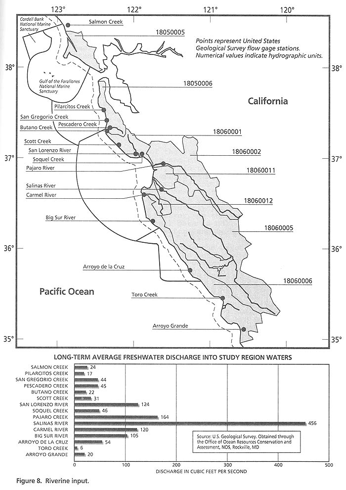
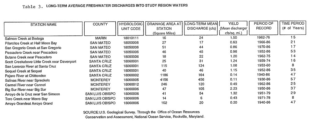
Freshwater flow from lands adjacent to the study region is low when compared to freshwater flows to the ocean in Northern California, Oregon and Washington. However, freshwater flow was higher in the central California area prior to diversion of water for agricultural and urban use. The Pajaro and Salinas rivers, which are adjacent to the central portion of the study area, provide the largest long-term average daily flow into the study region and drain the largest basins (Figure 8). The northern portion of the study area is almost entirely adjacent to one watershed. Only a small portion of the Marin County watershed is included to the north of the Golden Gate. The southern portion of the study area is adjacent to one thin coastal watershed draining the narrow coastal margin of the Big Sur and Los Padres Forest across Monterey and San Luis Obispo counties. The highest freshwater yield per unit area flows from the Big Sur River. This river is located in one of the small, localized drainage basins adjacent to the steep coastal terrain of the Big Sur and is probably less impacted by reservoirs, irrigation withdrawals, and municipal withdrawals as it is entirely within a protected forested area. USGS monitoring stations estimate a total of 1,228 cubic feet of fresh water enters the study area every second. (Table 3).
4. Water Quality [Part II TOC]
The water quality in the central California region is known to be very good (MMS, 1987). The periodic upwelling and extensive year- round mixing with the open ocean result in well-buffered, highly productive and well-oxygenated offshore waters. Water quality data from the National Status and Trends (NS&T) Program, as
Table 3: Freshwater discharges
well as State Monitoring programs, can be used to provide information on whether the water quality in the study area is improving or declining. It may also aid in assessing possible effects of contaminants on the health of the Monterey Bay ecosystem. Data on trace metals and organics are available from three components of the ecosystem from the NS&T data set: sediments, bivalves and fishes. Mussel contaminant data are of secondary value relative to sediment data for establishing the spatial distribution of contamination. However, examination of the distribution of sites with the highest levels of contamination has shown that organic contaminants, copper, silver and lead are highly associated with urban areas. Conversely, contaminants do not follow trends of common occurrence in rural areas (NOAA/NOS/ORCA, Tech. Memo. No. 49).
Within the central part of the study area four sites are sampled: two for sediments, fish and bivalves and two additional sites for fish and sediments only. In the southern portion one site is used to sample mussels only. A fourth site, also used to sample mussels only, is located to the north of the study area but within the Gulf of the Farallones NMS. Water quality data from the NS&T Program is only available for the past three years. Therefore, it is too early to confidently predict the existence of any trends in water quality. However, as the Monterey Sanctuary becomes operational and additional data is collected, it is a goal of the Sanctuary to use this data for long-term management issues.
Compared to other areas nationwide the offshore sample sites used in the Monterey Bay study area do not have elevated levels of contaminants. However, the estuarine waters of the study area are closed to shellfishing as a result of high coliform counts.
Marine water quality is also monitored by the California Water Resources Control Board through its State Mussel Watch Program and the National Pollutant Discharge Elimination System (NPDES) pursuant to the Clean Water Act, as well as by NOAA's National Status and Trends Program. The State Mussel Watch Program started in 1977, and is operated under interagency agreement with the Water Resources Control Board by the California Department of Fish and Game, Marine Pollution Laboratory. The Program involves monitoring toxic pollutant levels in resident and transplanted California mussels, resident Monterey Bay mussels, and transplanted freshwater clams at selected stations from coastal, bay, and estuarine areas. Hayes and Phillips (1987) report the major trends in trace metals and synthetic organic substances identified after a decade of monitoring in this program. There is a total of 81 monitoring stations managed by CDF&G via the Toxic Substance Monitoring (TSM) Program and the State Mussel Watch (SMW) Program within the watersheds of the Monterey Bay study area. Thirty nine of these exceed standard criteria (SWRCB, 1987, TSM Report No. 89-1; and SWRCB, 1987, SMW Report No. 87-2). Those measured which exceed "criteria" include cadmium, which is often found in high concentrations due to abundant natural sources.
In addition, a few specific areas within Monterey Bay have shown DDT concentrations above detectable levels. The California Department of Health and Human Services (DHS) is sampling the Bay's fish population for any toxins, including pesticides. The State Mussel Watch Program is collecting data that show certain non-point and point source coastal discharges are degrading water quality in specific areas. For example, State monitoring results show the following:
1) Resident California mussels from the Monterey Harbor area contain higher lead levels than elsewhere in California or worldwide.2) Freshwater clams transplanted to the innermost freshwater drainage (closer to the agriculture areas) that lead to Monterey Bay contain the highest levels of 26 pesticide and pesticide degradation products ever measured during the program. Chlordane, endosulfan, and DDT are some of the substances identified.
3) The highest levels of pesticides (dacthal, endosulfan, and endrin) ever measured in California mussels were found in mussels transplanted to the outer, more saline portions of the drainage to Monterey Bay.
4) High levels of tributyltin (used in anti-fouling paints) are found in mussels transplanted to semi-enclosed harbors with extensive boating activity. Low-levels of tributyltin (0.083 ppm, wet weight) were found in mussels in Elkhorn Slough.
The high level of lead found in the mussels of Monterey Harbor was traced to a slag heap of lead smelting waste which had been placed on the inner harbor shore as railroad fill. Lead isotopic analyses were used to identify this slag deposit as the principal source of the lead (Flegal et al., 1987). Lead (and zinc) may also be leaching into the bay from the wastes associated with the canneries that used to operate along Cannery Row (Loehr and Collias, 1983).
Elevated levels of mercury have been found in mussels at several locations along the California coast, including Año Nuevo Island. All sample locations are the site of very large pinniped and marine bird colonies. The elevated levels of mercury appear to be due to natural perturbations of the mercury cycle by higher organisms with anthropogenic sources being of secondary importance (Flegal et al., 1981).
Petroleum hydrocarbon concentrations were measured using Mussel Watch techniques. Resident mussels were shown to have higher than expected petroleum hydrocarbon body burdens in Carmel Bay, an area thought to be relatively contaminant free (Martin and Castle, 1984).
A wide range of pesticides have been entering the drainage to Monterey Bay from the surrounding agriculture areas for a long period of time. Studies other than the Mussel Watch Program have indicated other adverse effects on the water quality of the bay. The State Board Toxic Substances Monitoring program and the Department of Food and Agriculture studied DDT levels in soils and sediments of the Blanco Drainage Area. They concluded that non-degraded DDT from past legal agricultural use remains at significant levels in soils and becomes available to aquatic life when it is eroded in to waterways (Hays and Phillips, 1987). Both agencies suggest that better on-farm soil management practices could reduce the amount of DDT reaching the bay. DDT and its degradation products were found in the tissues of all eight species of marine fishes caught and analyzed from Monterey Bay (Shaw, 1972).
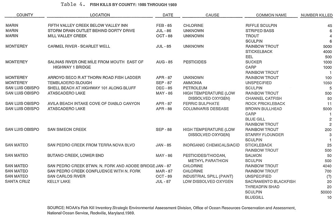
California Department of Fish and Game also inventories fish kills within waters of the state and attempts to correlate the kills to causes. Table 4 lists fish kills by county for 1985 to 1989 and shows that many of the kills can be attributed to a combination of both point and non-point source pollution. The California Department of Fish and Game, in cooperation with the California Department of Health Services, is conducting an aquatic toxicology evaluation program in Monterey Bay (Welden, 1988). The main objectives of the program are to determine the average chemical contaminants found in a range of the most common commercial and sport-caught fish in the bay and to give a current risk-assessment of the effects of consuming them. To date no significantly high concentrations of contaminants have been observed (J. Rote, pers. comm., 1992). Until further information is available and analyzed the California Regional Water Quality Control Board (RWQCB), Central Coast Region, has determined in its Draft Water Quality Control Plan (1989) that it can only classify Monterey Bay as a Potential Water Quality Limited Segment.
C. Habitats [Part II TOC]
1. Introduction [Part II TOC]
The Monterey Bay area is located in the Oregonian province subdivision of the Eastern Pacific Boreal Region. This province is characterized by a rich diversity of cold-temperate flora and fauna (Briggs, 1979). The Monterey Bay area, however, is home to a number of warm water invertebrate species characteristic of the California province to the south. This overlap and co-occurrence of warm and cold water species contributes to the diversity of the living natural resources in the Monterey Bay area.
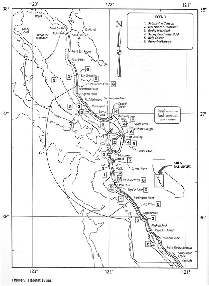
Habitats can be characterized by their water depth, distance from shore, and the type of substrate. The habitats in the Monterey Bay area are unusual because of the many diverse types that are found together in a relatively confined area (Figure 9). The six types of habitats found in the bay area are: 1) submarine canyon habitat, 2) nearshore sublittoral habitat, 3) rocky intertidal habitat, 4) sandy beach intertidal habitat, 5) kelp forest habitat, and 6) estuarine/slough habitat.
2. Submarine Canyon Habitat [Part II TOC]
Approximately 676 square nautical miles of canyon exist in the study area (NOAA Charts 18680 and 18700). Not only the canyon floor but the waters over the canyon provide unique habitat beyond the continental shelf in waters over 200 m deep. The waters of the bay support oceanic species of fish, birds, and marine mammals. Upwelling in the area supports most of the primary productivity for the entire bay. The canyon edge serves as a feeding area for endangered blue and fin whales, Pacific white-sided dolphins, northern right whale dolphins, Risso's dolphins, Dall's porpoise, and possibly the blue shark. Meso and bathypelagic fishes include the lanternfish (Myctophidae), sablefish, deepsea sole, and Pacific rattail. Fish, as well as euphausiid crustaceans (krill) and other organisms, compose a "deep scattering layer" that undergoes vertical migrations to the surface waters. The benthic community of the canyon is virtually unstudied except for an occasional grab or trawl taken by Moss Landing Marine Laboratories; however, recent video transects of the canyon down to 400-500 m by the Monterey Bay Aquarium Research Institute indicate a considerable diversity of organisms. Sponges, gorgonians, starfish, brittle stars, crinoids, and sea urchins appear to be the dominant large invertebrates (James Nybakken, pers. comm.,1989).
A team of USGS and NOAA workers using the submersible ALVIN discovered numerous biological communities nourished by seepages of sulfide and methane-rich fluids from the fan or valley-floor sediments. These deep-sea communities are significant as they not
only increase our understanding of the fluid-dynamics of large deep sea sediment fans but also provide basic knowledge of abyssal communities that include species also found in hot hydrothermal vents at spreading centers (EEZ News, October, 1989).
3. Nearshore Sublittoral Habitat [Part II TOC]
This habitat is found in the nearshore waters of the continental shelf in depths from just beyond the surf to 200 m depth. The food chain is based on planktonic productivity supported by upwelling of nutrient-rich waters from the Monterey Canyon. Pelagic organisms found in this habitat include phytoplankton and zooplankton, squid and octopus, and most of the important commercial fish (salmon, albacore, rockfishes, mackerel, and anchovy). Marine birds and California sea lions feed throughout the habitat. Shallow nearshore inhabitants include Harbor porpoise and Minke whales.
The nearshore benthic habitat is characterized by a soft bottom composed of unconsolidated sand and mud sediments. This is the most extensive bottom habitat in Monterey Bay. Two major groups of invertebrates are found in this habitat: 1) the infauna, which live buried within the sediment, comprise about 90 percent of all the bottom-dwelling organisms; and, 2) the epifauna, which live on or crawl or move over the bottom. Both groups are unevenly distributed throughout the bay. Many benthic organisms have a pelagic phase in their life histories (Nybakken, 1982).
The subtidal invertebrate fauna of the shallow offshore waters are found in a far greater number of species than are the intertidal fauna. For example, the sandy intertidal habitat has only 29 species and/or genera, the subtidal habitat includes more than 400 species and/or genera. However, less is known about these subtidal species than is known about the intertidal species (James Nybakken, pers. comm., 1989). The dominant invertebrates in shallow subtidal waters are polychaetes, molluscs, and crustaceans. Crustaceans are dominant in shallow areas; polychaetes are dominant in deeper waters.
4. Rocky Intertidal Habitat [Part II TOC]
This habitat is found on rocky substrate between the lowest tidal level and the highest tidal level. Organisms living in this area must be able to withstand periodic desiccation, high temperature and light, low salinities, and strong wave action (Nybakken, 1982). Variation in the degree of exposure to these environmental factors can create marked zonation patterns within this habitat (Foster et al., 1988). Marine plants are primarily red, brown, and green algae. The invertebrates include mostly sessile species such as mussels, barnacles, and anemones. Mobile grazers and predators include crabs, amphipods, littorine snails, limpets, sea stars, and sea urchins. Tidepool fish include the striped surfperch, tidepool sculpin, tidepool snailfish, and cabezon.
Rocky intertidal habitats are probably the most well studied of all habitats in and adjacent to Monterey Bay. These habitats are not uniform within the bay, but vary in composition within short distances. All of the Areas of Special Biological Significance (ASBS) found within the study area have rich abundances of invertebrate species. In addition, Asilomar Beach and Point Sur are well known areas for invertebrates and the Fitzgerald Marine Reserve has one of the largest intertidal reefs in California supporting an extremely diverse and abundant array of invertebrate species.
5. Sandy Beach Intertidal Habitat [Part II TOC]
Sandy beaches are the dominant intertidal habitat in Monterey Bay. Most animals capable of tolerating the stresses of the intertidal area are burrowing organisms. This is a very dynamic habitat with constantly shifting sands caused by wave action and the longshore transport of sand. The overall productivity of this habitat is lower than that for rocky intertidal habitats (Nybakken, 1982).
Benthic diatoms are the only marine algae that may be present. Oakden and Nybakken (1977) found 29 genera or species of animals in transects taken over the course of a year. Polychaete worms, bivalve molluscs, and crustaceans were the predominant invertebrates found. Sand dollars and gastropod molluscs are also found here (Wilson, 1986). The only fish that are common are those that use sandy beaches for spawning (e.g., the surf smelt).
6. Kelp Forest Habitat [Part II TOC]
There are approximately 200 nautical miles of kelp in the study area. There is a continuous stretch of kelp along the coast from Año Nuevo to Cambria excluding the area from Santa Cruz to Monterey where the sandy substrate is unsuitable for kelp holdfast attachment. North of Año Nuevo kelp distribution is sparse and almost non- existent north of Pescadero Point. Kelp is a large brown algae which attaches to rocky substrate and grows in water depths from about 2 m to 20 m. The floating portions of these plants form dense canopies on the sea surface. Kelp forests provide critical habitat for encrusting animals such as sponges, bryozoans, and tunicates, as well as for juvenile fish, molluscs such as abalone, algae, and for other invertebrates. Fish associated with kelp beds include greenling, lingcod, bocaccio, and many species of surfperches and rockfish. Gray whales have been reported to feed near kelp forests and to seek refuge in them from predatory killer whales (Baldridge, 1972). Kelp also provides a food resource for fish, and for grazing and detritus- feeding invertebrates, such as isopods and sea urchins. Predators, such as sea stars and sea otters, are also active there.
Kelp detached and transported during storms provides a source of food for other local habitats. Sandy beach fauna utilize the kelp washed up on the beach. Kelp material that sinks may provide a source of energy for deep water benthic organisms. Fish, particularly juvenile rockfish, utilize the habitat provided by rafts of drifting kelp (Foster and Schiel, 1985).
Sea otters and harbor seals are commonly associated with kelp forests in this area, and otter biology and the effects of sea otters on kelp communities have been the subject of numerous completed (reviewed in Van Blaricom and Estes, 1988) and continuing studies. The exact effect that sea otters have on the community structure of the Monterey Bay kelp forests remains unclear. Sea otters are known to prey on sea urchins. Sea urchins are known grazers on kelp. Comparisons of kelp forests with and without sea otters have shown that sea otter predation on sea urchins has a beneficial effect on the distribution and growth rates of kelp. Sea otters have been described as "keystone species" which play a major role in determining community structure (Estes and Palmisano, 1974). However, because other factors also affect kelp distribution and abundance, this role of sea otters is not totally accepted (Foster and Schiel, 1985). Kelp does appear to be increasing in distribution in areas where sea otters live (Reidman, 1986).
7. Estuaries and Sloughs [Part II TOC]
Estuaries provide some of the most productive habitats in the world. These habitats are critical not only for the local ecosystems in which they appear but also ecosystems elsewhere through the species they support (NOAA and FWS, 1991). For example, in the Monterey Bay area, the adjacent estuaries, slough and wetlands not only provide critical habitat for some stage in the life-cycle of a number of plants, fish, shellfish and other wildlife but also provide protection from storm and wave damage, water quality improvement through filtering and processing of agricultural and urban wastes, and recharge of aquifers.
The dramatic loss of original coastal wetlands (75% in California) as well as Nationwide emphasizes the value of those remaining estuaries for the species that depend upon them for their survival. For example, the tidewater goby Eucyclogobius newberryi (more common in the southern portion of the study area), and the stickleback Gasterosteus aculeatus leiurus (more common in the northern portion of the study area) are both candidate species for Federal listing as Species of Special Concern due to their limited numbers and distribution, are distributed throughout the estuarine and slough habitats of the Monterey Bay area (Cailliet, pers. comm. 1991). In the center of Monterey Bay and east of Moss Landing is Elkhorn Slough, the largest remaining coastal wetland area between Morro Bay and San Francisco Bay. The importance of Elkhorn Slough to the area's ecosystem and the public was recognized when it was designated a National Estuarine Research Reserve in 1981. Numerous other smaller but also valuable estuaries, sloughs and wetlands exist throughout the study area, especially at the mouths of the major rivers that enter the Monterey Bay area, such as Pescadero and Soquel Creeks, and the San Lorenzo, Pajaro, Salinas, Carmel, Little Sur and Big Sur Rivers. Other smaller areas of freshwater input to the ocean include, but are not limited to: Pillar Point marsh, Miramonter Point wetlands, Parisima Creek, Tunitas Creek, San Gregorio Creek, Pompino Creek, Mill Creek, Pescadero Marsh, Big Creek, Limekiln Creek, Carpolare Creek, Salmon Creek, Laguna Salada Wetland, and San Pedro Creek. These areas where rivers meet the sea provide a rare and critical series of unique habitats for a wide variety of species that contribute to the national significance of the Monterey Bay area.
D. Biological Resources [Part II TOC]
1. Introduction [Part II TOC]
The diversity and abundance of species in the Monterey Bay area can be attributed in part to the location of the bay within the broad transition zone between the cold water Oregonian Province to the north and the warm water California Province to the south. Not only do many northern and southern species coexist in the transition zone but there are also endemic species which seem to survive only in this zone. The fossil record suggest that this transition zone has existed for many millions of years, and that it has been a likely site of evolution for species that later became established as characteristic species of either Oregonian or Californian Provinces.
Thus Monterey Bay supports a wide array of temperate cold-water species, with occasional influxes of warm-water species. This species diversity is directly related to the diversity of habitats described above and the location of Monterey Bay within a broad transition zone providing a complex gradient of changing environment in which the relative proportions of species changes from north to south. All the biological resources within the Sanctuary will be protected by Sanctuary designation including but not limited to, plankton, algae, invertebrates, fish, seabirds, turtles and marine mammals.
2. Plankton [Part II TOC]
Plankton species present in the Monterey Bay area are primarily characteristic of the cold-water California region, but also include a few warm-water species (Holton et al., 1977; Riznyk, 1977; Garrison, 1979). Upwelling from the canyon carries some deep water species close to shore. Diatoms are the primary component of the phytoplankton. The spring to late summer period of upwelling with its nutrient-rich waters causes a seasonal variation in the standing stock of phytoplankton. The highest primary productivity is associated with the upwelling period; the lowest during late fall through winter when the warmer Davidson Current predominates and upwelling ceases. Dinoflagellate blooms occur in the fall in the warmer waters. Satellite imagery indicates that phytoplankton concentrations are frequently higher in the northern regions of the bay, with low phytoplankton waters entering the bay from the south around Point Pinos (Hauschildt, 1985).
Unlike phytoplankton, which are limited to the euphotic zone (approximately the upper 100 m), zooplankton occur at all depths and are able to migrate vertically up to several hundred meters. The phytoplankton are fed upon by a variety of zooplankton such as ciliates, copepods, euphausiids, and pelagic tunicates. Zooplankton are in turn an important food source for fish and other organisms. Dense concentrations of euphausiids occur in the surface waters and in deeper layers from 100 to 400 m from April to November (Barham, 1956; Schoenherr, 1988). These swarms serve as food for a variety of adult fishes, whales and sea birds (Harvey, 1979; Schoenherr, 1988), and for juvenile fishes which prey on euphausiid eggs and larvae (NOAA Rockfish Recruitment Cruise Reports, 1986-1988). Dense swarms of gelatinous pelagic tunicates also occur periodically from early spring to mid-fall (Barham, 1956). In fall 1986, aggregations of euphausids, dominated by the krill Euphausia pacifica, attracted a large number of endangered blue whales to feed in Monterey Bay (Schoenerr, 1988).
3. Algae [Part II TOC]
Large marine algae, or seaweeds, are diverse and abundant in the Monterey Bay area. The extent of this diversity is shown by the presence of over 450 of the 669 species of algae described for California (Abbott and Hollenberg, 1976). The area has the largest marine flora of the temperate northern hemisphere, with numerous endemic species and the only population of one large understory kelp (Eisenia arborea) between southern California and Canada. It has been suggested that Monterey Bay may represent a biogeographic boundary for the distribution of algae; this, however, may be because the bay area has been studied more intensively than others (reviewed in Foster et al., 1988).
The seaweeds of the Monterey Bay area are composed of three main phyla: red algae (Rhodophyta: 69 percent of all species), brown algae (Phaeophyta: 20 percent), and green algae (Chlorophyta: 10 percent). They occur primarily in areas of rocky substrate and only rarely in water deeper than 40 m (Abbott and Hollenberg, 1976). The most extensive algal communities are dominated by forests of giant kelp (Macrocystis pyrifera) and bull kelp (Nereocystis leutkeana). Bull kelp rejuvenates itself annually; giant kelp is generally perennial, growing all year.
Kelp beds are continuous from San Simeon in the south of the study area to Monterey city. Within Monterey Bay from Monterey City to south of Santa Cruz there are no kelp beds due to the sandy substrate of the shore. Kelp beds are thick off of Santa Cruz and intermittent up to Año Nuevo. Kelp is rare from Año Nuevo to Half Moon Bay, the northern limit of its distribution. The Santa Cruz County coast between Terrace Point and Point Año Nuevo has changed from almost total dominance of giant kelp in 1911 to an increase in the number of bull kelp stands (Yellin et al., 1977). Although sea otters may produce further changes, the primary factors affecting these kelp forests appear to be storms and substrate composition (reviewed in Foster and Schiel, 1985).
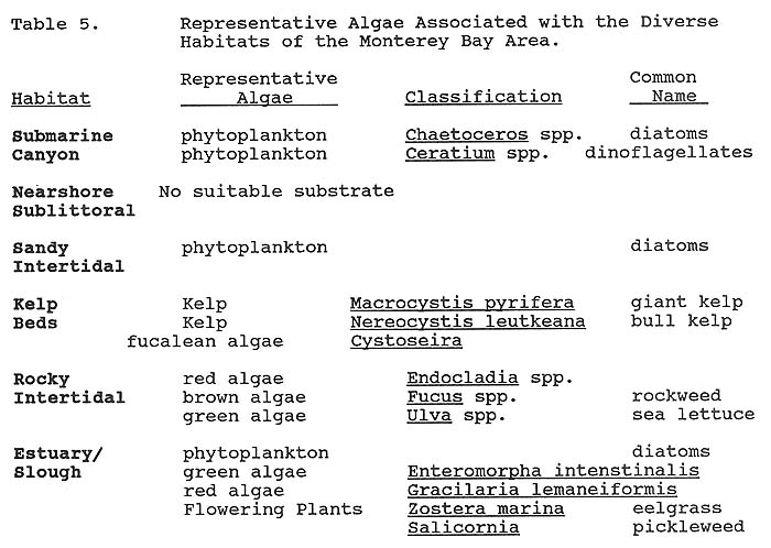
Table 5 shows a brief listing of some of the types of algae associated with the different habitats encompassed by the Sanctuary study area. In addition to the marine and coastal types of algae the estuary and slough habitats provide sheltered areas for an abundant growth of marine algae as well as specifically adapted
vascular plants such as eelgrass and pickleweed that in turn provide rich micro-habitats for other organisms.
4. Invertebrates [Part II TOC]
The Monterey Bay area has one of the most diverse and species- rich invertebrate faunas of any marine area of similar size in the entire world (James Nybakken, pers. comm., 1989). This diversity can be illustrated by the following facts: 1) Of the 33 or so invertebrate phyla, the only ones that have not been collected in Monterey Bay are Loricfera and Pogonophora; 2) For some groups (e.g., shallow water starfish), Monterey Bay may well be the richest area in the world; 3) There may be more species of molluscs in Monterey Bay than in any other locality outside of tropical or semi-tropical areas (Smith and Gordon, 1948, in J. Nybakken, pers. comm.). Those researchers listed 725 species of molluscs from the Monterey Bay alone. For limpets and chitons, the bay region is the richest and most diverse in the world (David Lindberg, pers. comm., 1989); 4) Monterey Bay is a faunal break on the Pacific Coast for molluscs (Valentine, 1966). The bay is the northern limit of the range for many southern species and the southern limit of the range for many northern species; 5) Monterey Bay has a relative abundance of some species which are uncommon or rare where they occur. This includes the strange animal named Poeobius, which has been considered a missing link between the annelids and the sipunculans. Also, the cnidarian Tetraplatia, which is rare in the world's oceans, has been taken in abundance in Monterey Bay.
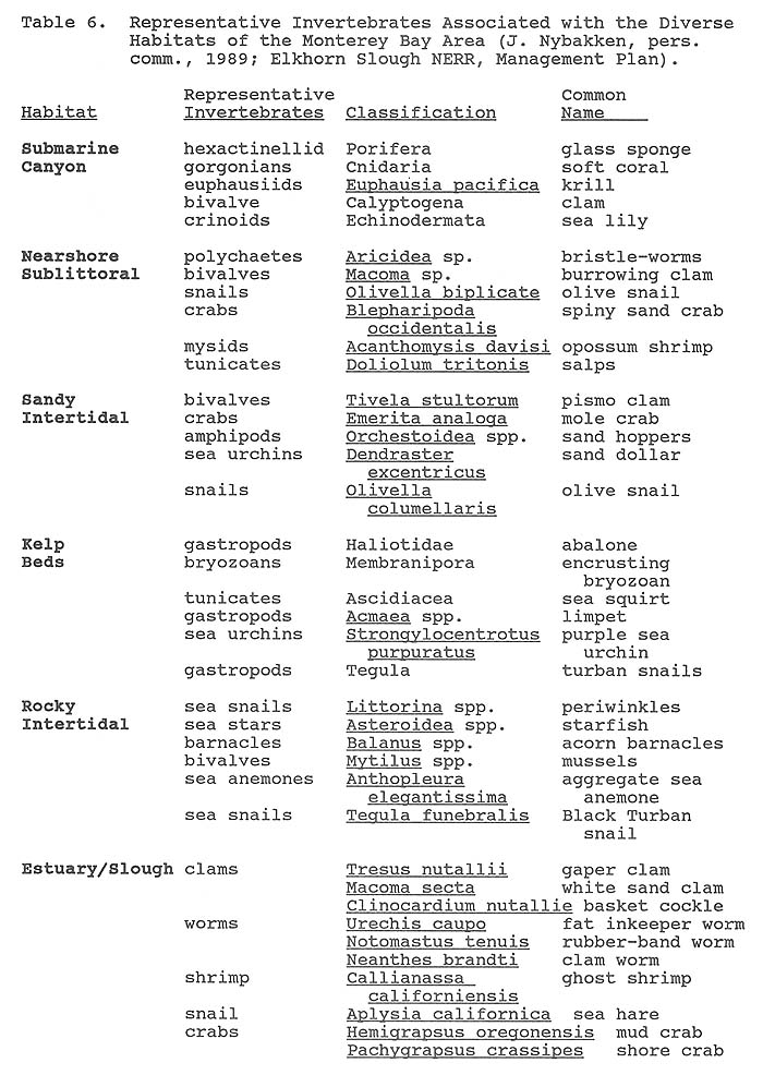
The distribution, species composition, and abundance of the invertebrate fauna in Monterey Bay are determined by many factors. The submarine geology and the types of rocky substrate or unconsolidated sediments, the submarine canyon and associated upwelling, the offshore currents and circulation patterns, the kelp forests, and the presence of mammal predators all influence the niches occupied by the various species (Table 6).
The rocky intertidal habitat support the widest array of invertebrate species (Ricketts et al., 1985; Smith and Carlson, 1975; Morris et al., 1980). Particularly rich and diverse areas within this class of habitat and encompassed by the Sanctuary study areas include the State designated Areas of Special Biological Significance, as well as Asilomar Beach, the Fitzgerald Marine Reserve and Point Sur. Characteristic species include periwinkles, isopods, barnacles, limpets, sea snails, crabs, chitons, mussels, sea stars, and anemones. Research into the recruitment patterns of crabs and crab bed locations in northern Monterey Bay gives an example of how the distribution of a species can be influenced by local circulation patterns. Temporal tracking of several species of crabs, including the commercially important Dungeness crab, indicates that they are not produced locally but are advected into local waters by the southerly flowing California Current (Monty Graham, pers. comm., 1989).
Invertebrates found in the sandy beach intertidal habitat are dominated by numerous species of polychaete worms, crustaceans, and molluscs. Nearshore benthic invertebrates include polychaetes and other worms; molluscs such as snails and bivalves; ostracods, amphipods, isopods, and other crustaceans; and starfish. Squid, octopus, jellyfish, salps, heteropods, and euphausids are some of the macro-invertebrates found in the pelagic environment. Numerous larval invertebrates are also found there during their planktonic stages of development. Invertebrates found in deep water and the canyon include various species of hexactinellid sponges and gorgonians (soft corals). Nybakken (pers. comm., 1989) has collected specimens of the clam Calyptogena, which is the same genus as the giant clams of the thermal vent areas of the Galapagos.
Estuarine and slough habitats can support widely diverse and abundant invertebrate species. Historical studies of the Elkhorn Slough area showed approximately 371 species of benthic invertebrates (excluding oligochaetes) (Nybakken, 1977). The best known inhabitants include clams such as the gaper, white sand and the basket cockle. In addition, worms, shrimp, snails and crabs actively assist in the process of converting the slough's rich organic matter into food and in the process providing larger organisms such as fish and birds with a plentiful food base. Invertebrate species harvested by commercial and recreational fishermen include squid, spot prawn, Dungeness crab, abalone, and pismo clam.
5. Fishes [Part II TOC]
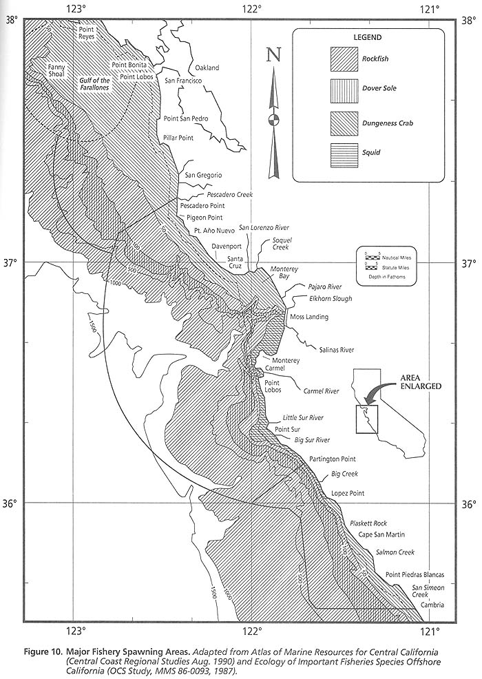
The diversity and abundance of the fish fauna in the Monterey Bay area is a significant resource. Generally, the area exhibits the very rich cold-temperate fish fauna of the Oregonian province (Briggs, 1979). The same environmental factors that determine the distribution, abundance, and species composition of the other living resources of the area also affect the fish communities. In addition to the presence of the submarine canyon and the upwelling of nutrients, kelp beds provide shelter and food for juvenile and adult fish, while offshore rocky reefs are prime feeding and spawning areas for many species of fish (Figure 10).
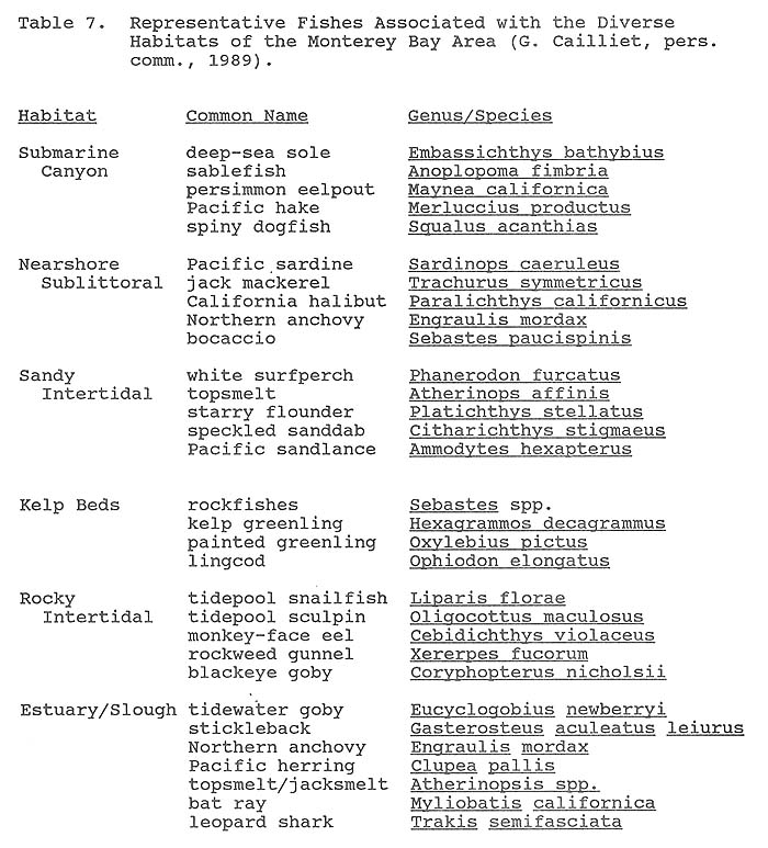
Approximately 345 species of fish are found within the study area. The numbers of species most "common" to have been identified and associated with the various habitats include: Canyon and deep bottom, - 93; Rocky intertidal (tidepools), - 24; Subtidal (kelp), - 34; Estuaries, Sloughs and Sandy intertidal - 68; Nearshore sublittoral (soft bottom) - 33; Epipelagic - 25; and Meso- and Bathypelagic - 69 (Greg Cailliet, pers. comm. June, 1991).
The diverse habitats of the area each have their own characteristic assemblage of fish (Table 7). Although the fish fauna of Monterey Bay are relatively well known (Kukowski, 1972; Cailliet et al., 1977, in Anderson et al., 1979), fish in the submarine canyon are characterized by a variety of little known meso-and bathypelagic species. Because the canyon allows deep-living species to come close to shore, many uncommon deep-sea fishes have been taken in Monterey Bay. Anderson et al., (1979) reports fishes belonging to 41 families were captured in the bay by Moss Landing Marine Laboratories or by fishermen. Several of the species were previously unrecorded in the area, while others were extremely rare or far beyond their normal range. The persimmon eelpout (Maynea californica) was once thought to be an extremely rare species. It has recently been found to be abundant in the Monterey Canyon in association with its own unique bottom drifting seaweed habitat (Cailliet and Lea, 1977). A rare, deep-water North Pacific frostfish (Benthodesmus elongatus pacificus), a species unknown in California, was caught in Monterey Bay in 1968 (Anderson and Cailliet, 1975). A rare prowfish (Zaprora silenus) was caught on the north shelf of the submarine canyon in 1973 (Cailliet and Anderson, 1975). The commercially important sablefish spawns in the deep waters of the canyon but lives in relatively shallow waters as juveniles (Cailliet and Osada, 1988).
Fish of the nearshore subtidal habitats exhibit the greatest diversity. This habitat includes many commercially important fish such as the pelagic schooling species (northern anchovy, Pacific herring, jack mackerel, sardine), the large predators (king salmon, sablefish, sharks), and some demersal species (English and petrale sole). Many important species of rockfish are found over rocky reefs. Monterey Bay was the southern extent of spawning for the king (chinook) salmon, although they do not presently spawn in any of the Bay's streams.
Sandy intertidal areas are used by small pelagic species (grunion and smelt) that use the beaches of the inner bay for spawning. Other species that forage near sand flats include the surf perch, striped bass, jack smelt, sand sole, sanddab, and starry flounder.
Most of the finfish found in shallow rocky reefs are also common in kelp beds. The kelp canopy, stipes, and holdfasts increase the available habitat for pelagic and demersal species and offer protection to juvenile finfish. Greenling, lingcod, and numerous species of rockfish are the dominant fishes. The rocky intertidal habitat is characterized by a rather small and specialized group of fish adapted for life in tide pools and wash areas. The most representative species are the monkey-face eel, rock eel, dwarf surfperch, juvenile cabezon, sculpins, and blennies (California Department of Fish and Game, 1979).
Few fishes live year-round in sloughs although some fish such as the tidewater goby Eucyclogobius newberryi and the stickleback Gasterosteus aculeatus leiurus depend upon the more brackish upper reaches of the estuarine habitats. Full time residents such as the staghorn sculpin and the bay pipefish depend upon the mud, eelgrass and other microhabitats to feed, reproduce and hide from predators (Silberstein and Campbell, 1989). Mid-water swimmers such as the Northern anchovies (Engraulis mordax), Pacific herring (Clupea pallis), topsmelt and jacksmelt (Atherinopsis spp.) also use the area for feeding while simultaneously using the microhabitats for protection from predators (Silberstein and Campbell, 1989). Large marine predators such as bat rays (Myliobatis californica) and leopard sharks (Trakis semifasciata) forage extensively on the benthic fauna of the more saline lower reaches of the estuaries (Silberstein and Campbell, 1989). Sardines were the basis for an extensive fishery in the 1930's. Overfishing caused stocks of the Pacific sardine to decrease until the fishery collapsed.
6. Seabirds [Part II TOC]
The Monterey Bay area historically has been recognized as a uniquely important region of seabird occurrence (Loomis 1895, 1896; Beck 1910). Several environmental features are responsible for the diverse assemblage of birds in the area:
- the bay is located on the Pacific Flyway, allowing the birds a place to stopover during both north and south migrations between southern wintering grounds and northern breeding sites.
- the upwelling of nutrient-rich waters adjacent to the submarine canyon support highly productive food webs which provide abundant seabird prey.
- plumes of upwelling in the outer shelf regions also act to concentrate prey near the surface in "fronts" at the plume edges (Briggs et al., 1983a, 1984, 1987a, b; Briggs and Chu, 1986, 1987).
- the availability of food in a bay protected on three sides allows birds that normally feed far offshore to seek shelter during storms.
- the diversity of habitat types along the shore increases the variety of bird species which utilize the bay area.
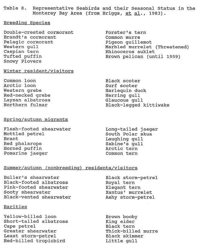
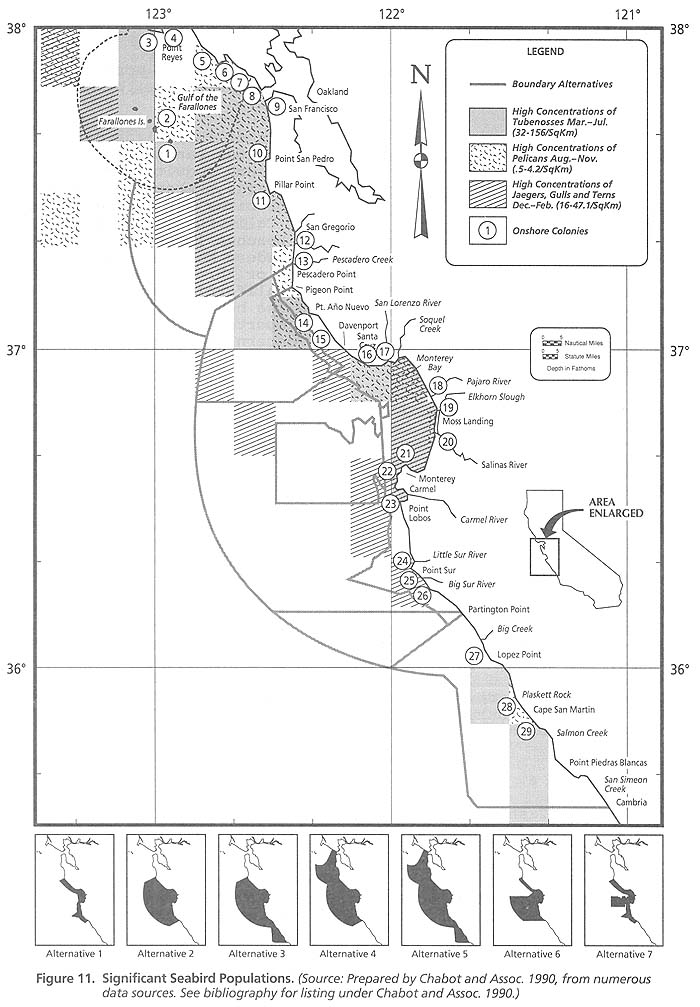
Ninety-four seabird species are known to occur in the Monterey Bay region, of which about thirty species predominate in their preferred seasons and habitats (Briggs and Chu, 1987). Table 8 lists some important seabirds and their seasonal status. Thirteen species are resident breeders or former breeders within the region.
Common breeding species include Brandt's cormorants, western gulls, pigeon guillemots, and common murres (Dohl, 1983). The location of important seabird colonies are shown in Figure 11.
The majority of seabirds occur here as non-breeding residents/visitors and spring/autumn migrants. The area is important habitat for visiting autumn and winter populations of ashy storm- petrels, California brown pelicans, sooty and short-tailed shear- waters, western grebes, common murres, marbled murrelets, Cassin's and rhinoceros auklets, surf scoters, and several species of gulls. Spring and fall migrant species include phalaropes, Pacific loons, common and arctic terns, and pomarine and parasitic jaegers. Four species of endangered birds are found in the area: the short-tailed albatross, the California brown pelican, the American peregrine falcon, and the California least tern. One species, the western snowy plover, is a candidate species for being listed as endangered or threatened by the U.S. Department of the Interior. The California brown pelican nested at Point Lobos until 1959 (Baldridge, 1974). The brown pelican now breeds during the summer in southern waters and migrates into the area in large numbers in September and October. They currently roost on Año Nuevo Island, Elkhorn Slough, and Point Lobos. The California least tern nested at Moss Landing early in the century. In 1973, the coast south of San Francisco contained only 20 colonies with a total of fewer than 700 pairs (Udvardy, 1977). Peregrine falcons feed along the shores of the bay, especially around Point Lobos and Elkhorn Slough. Five nests have been identified in Big Sur (Roberson, 1985).
Offshore distributions and concentrations of seabirds show the importance of the Monterey Bay area marine ecosystem as a habitat for seabirds (Figure 11). There are a total of 94 species of seabirds which can be found in 23 main rookeries and colonies in the Monterey Bay area. Figure 11 also shows the areas of high concentration for significant populations of seabirds in the study area. It also shows a total of 23 rookeries and colonies within the study area. Significant populations include pelicans, tubenoses, jaegers, gulls and terns. The highest concentrations are found in the northern portion of the study area. Ashy storm-petrel populations currently number less than 10,000 birds. About 85% of them breed on the Farallon Islands. Almost all of them come to Monterey Bay to feed over the submarine canyon during the summer and fall (Roberson, 1985).
Additional facts about several species further indicate the importance of the Monterey Bay area to seabirds. The southernmost relic population of the severely threatened marbled murrelet occupies several isolated sites in the Santa Cruz Mountains. Año Nuevo Island was recently colonized by rhinoceros auklets (their southernmost confirmed nesting site) and contains the largest colony of western gulls in the region (Lewis and Tyler, 1987). The
Figure 11: Seabird distribution
seacliffs of Santa Cruz and Monterey counties support more nesting pigeon guillemots than the Farallon Islands, which has the largest single colony in California.
During spring migration, large numbers of shorebirds gather on the beaches. Common migrant shorebirds include sandpipers, turnstones, plovers, sanderlings, willets, and godwits. Many of these species also winter in the area in large numbers. Elkhorn Slough seasonally harbors over 30,000 shorebirds during migrations (Stenzel et al., MS). Nearly a fifth of California's breeding population of snowy plovers nest on the beaches in the area and is especially common in the vicinity of Pescadero Marsh. The plover is a candidate species for the endangered or threatened list as well as a Species of Special Concern in California (Remsen, 1978). Sea ducks and geese use the coves along the bay for staging during spring migration. Año Nuevo Bay is an important wintering site for Harlequin ducks (a species of Special Concern) and brant.
7. Turtles [Part II TOC]
Four species of sea turtles are found in the study area. The Leatherback (Dermochelip coriacea) is the most common followed by the Green (or Black) turtle (Cheloia myslas agassizi), the Loggerhead turtle (Caretta caretta) and an occasional Olive Ridley (Lepidochelip olivaceas). There are no sea turtle nesting areas in the study area. They are mostly seen during their foraging activities in the summer and early fall. Most appear during the warmest sea temperatures (above 16 degrees C and most common above 18 degrees C). Many of the turtles distributions seem to be regulated by the 16 degree C isotherm (Pers. comm., Scott Eckert, NOAA/NMFS, 1991).
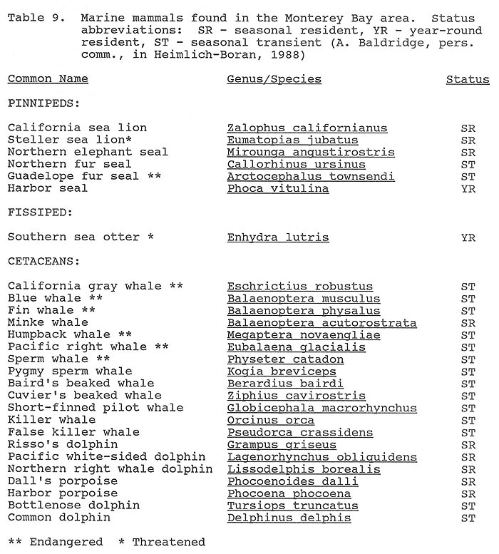
8. Marine Mammals [Part II TOC]
Twenty-six species of marine mammals have been observed in the Monterey Bay area, including five species of the sub-order pinnipeds (seals and sea lions), one species from the sub-order fissipeds (sea otter), and twenty species of the order cetaceans (whales and dolphins) (Table 9). Representatives of the order and each sub- orders in the Monterey Bay area are described further below.
a. Pinnipeds [Part II TOC]
Figure 12 shows the principal pinniped breeding and haulout areas and offshore concentrations. There are a total of 9 rookeries/colonies in the study area. The five species of pinnipeds considered common in the Monterey Bay area include California sea lions, Steller sea lions, Northern elephant seals, Northern fur seals, and Pacific harbor seals. An additional species, the Guadaloupe fur seal, has been reported from records of
Figure 12: Principal haul-out areas
sick animals stranded on the beach. One juvenile male was found along the shore near Fort Ord in April 1977 (Webber and Roletto, 1987). Año Nuevo is the most important pinniped breeding site in the area and the most important pinniped rookery and resting area in central and northern California.
In any season, California sea lions are the most abundant pinniped in the area (Bonnell et al., 1983). They breed farther south along the coast in the summer, then migrate northward, reaching their greatest numbers in the Monterey Bay area in autumn. Sea lions haul out on offshore rocks and islands. The greatest numbers occur on Año Nuevo Island, with a fall population of more than 7,000 animals. Both haul-out sites and foraging grounds are essential to the species' health. Popular haul-out sites include the offshore rocks of the outer coast between the Monterey Peninsula and Point Sur and the long breakwater of Monterey Harbor.
Although Año Nuevo Island has the largest breeding population of Steller (northern) sea lions south of Alaska (Loughlin et al., 1984), the numbers of this species have been declining throughout their range over the last 30-year period. Due to their rapid decline, NOAA on November 6, 1990 listed the Steller sea lion as a threatened species (55 FR 49204) with an effective date of the final rule on December 4, 1990. These sea lions presently breed almost exclusively on offshore rocks to the northwest of Año Nuevo Island. The latest aerial survey (in the summer of 1985) showed the population to be 1,169 animals, including 328 pups (Bonnell and Le Boeuf, unpubl. data). The population declined to a low during the 1983 ocean temperature anomaly (El Niño), but recovered to pre-El Niño levels in 1984 and 1985. NOAA will be developing a "recovery plan" for this species with special attention to rookery areas such as Año Nuevo.
Northern elephant seals breed in the winter months and then disperse to feed in pelagic waters throughout the eastern North Pacific. A portion of the population returns to the colony later in the year to undergo an annual molt. Peak abundances occur on land in the spring when juvenile males and females haulout to molt. The largest populations are on Año Nuevo Island and the adjacent mainland point. The breeding population at these locations presently numbers about 3,500 animals (Le Boeuf, unpubl. data). The spring population on land exceeds 4,000 animals. Estimates based on population structure indicate that elephant seals of the Año Nuevo colony account for about 4% of the entire world population of this species (M.L. Bonnell, pers. comm., 1989).
Pacific harbor seals are year-round residents in the area. They haul out at dozens of sites along the coast from Point Sur to Año Nuevo. Peak abundance on land is reached in late spring and early summer when they haul out to breed, give birth to pups, and molt. More than 1,800 animals were counted on land in this area during a survey in 1982. This represents more than 11% of the entire state population (Bonnell, et al., 1983). A summer of 1986 census counted 1,364 seals on only 38 of the 72 known haul out sites in the area (Hanon, et al., 1987). Favorite haul out sites are isolated sandy beaches and rocky reef areas exposed at low tide. Harbor seals also use the estuarine habitat of Elkhorn Slough. A recent census of harbor seals at Elkhorn Slough shows the mid-August population increasing from 40 in 1986 to 120 in 1990 (Elkhorn Slough NERR, monitoring data, 1990).
Northern fur seals occur in the open waters over the Monterey Canyon in winter and spring. They feed offshore after migrating from the Pribilof Islands. The greatest density of animals are found well offshore over the continental slope in waters from 100 to 1,000 fathoms (200 to 2,000 m) depth. Northern fur seals rarely haul out on land, although they are occasionally seen on Año Nuevo Island. They have a declining population presently estimated at 1.2 million animals. Many causes have been attributed to this decline, including entanglement in marine debris. This species has been proposed for designation as a depleted species by the NOAA.
b. Cetaceans [Part II TOC]
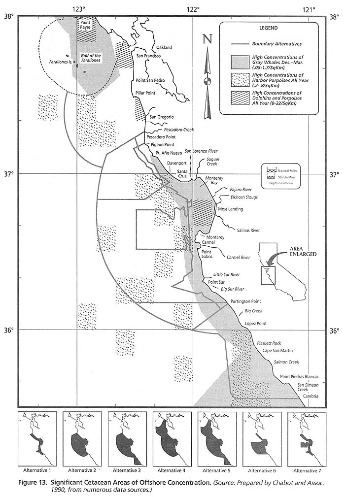
Of the twenty species of cetaceans seen in the Monterey Bay area (Table 9), about one-third occur with frequency. Six of the whales are listed as endangered species: the blue, fin, humpback, gray, right, and sperm. Figure 13, taken from Chabot and Associates, (1991), shows the areas of high concentration for grey whales, porpoises and dolphins. Other cetaceans such as humpback whales, right whales, minke whales, fin whales, blue whales and killer whales also seasonally inhabit the waters within the study area. The highest concentration areas of cetaceans are within the southern and central portions of the study area.
Gray whales are seasonal migrants (Figure 13). They travel close to shore and are the object of most of the whale watching in the area. They pass through the area twice on their yearly migration from Alaska to Baja California where they breed and then return. Reilly (1984) estimated the 1980 population of gray whales to be 15,000 animals.
Blue whales have significantly increased in numbers within and adjacent to Monterey Bay. Once considered only a summer visitor of limited numbers, blue whales have become a major constituent of the cetacean fauna from late spring until late autumn or early winter. Over 40 animals were counted in one day in Monterey Bay in the summer of 1986 (T. Dohl, pers. comm., 1989). Less than 2,000 blue whales exist in the eastern north Pacific (Haley, 1987). They migrate from northern feeding areas to waters off Baja California and Central America in the fall.
Minke whales are one of the largest whales that feed close to shore within Monterey Bay. Up to 12 animals are regularly seen in the southern bight of the bay and south to Point Sur during summer (A. Baldridge, pers. comm., in Heimlich-Boran, 1988).
Fin whales have increased in numbers and length of stay in the area in recent years. This species utilizes the Monterey, Soquel, and Carmel canyons for feeding. They are found in greatest numbers at the heads of each of these canyons in depths of 200 m to 2000 m (T. Dohl, pers. comm. 1989).
Humpback whales are often seen in nearshore waters from 100 m to 200 m depth. Although still an endangered species, their numbers have increased dramatically throughout central California beginning in the early 1980's. At first limited to the general area of the Farallon basin, they are now found in coastal waters from Point Sur to Pillar Point from late-April to mid-December.
The Pacific Right whale is an extremely endangered species. Fewer than 200 individuals may inhabit the entire North Pacific (Braham and Rice, 1984). Little is known about this species; its breeding areas are unknown but presumed to be on their wintering grounds in warmer waters. No right whales have been seen in Monterey Bay, but they were seen in 1986 and 1987 in the waters off of Half Moon Bay, north of Año Nuevo (Scarff, 1987).
Sperm whales are occasionally seen offshore at the mouth of the Monterey Canyon. Pilot whales, false killer whales, and two species of rare beaked whales have also been sighted. Killer whales have been seen throughout the bay, occasionally attacking gray whales (Baldridge, 1972).
Two species of porpoise are commonly found in the bay: Dall's porpoise and the harbor porpoise. The harbor porpoise is usually found over sandy bottoms just off the surf in the north central part of the bay. Dall's porpoise is seen frequently along the edge of the canyon. Pacific white-sided dolphins, northern right whale dolphins, and Risso's dolphins are the most numerous cetaceans in the area. All three species will often travel together in a school. Bottlenose dolphins are found in small numbers (12-18) within the bay seemingly on a year-round basis. Common dolphins are found all year, sometimes in schools of 400-600 animals. This species is normally considered a warm water animal and was once thought to extend north only to Point Conception. Both dolphin species have increased in numbers in recent years (T. Dohl, pers. comm., 1989).
c. Fissipeds [Part II TOC]
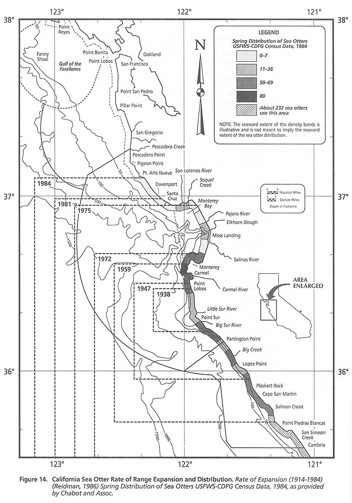
There are approximately 1,250 individual sea otters within the study area (Chabot and Associates, 1990). The range of the sea otters within the study area is approximately 130 square nautical miles (Figure 14). Since the southern portion of the study area includes the California Sea Otter Game Refuge, Boundary Alternatives 3 and 5 contain the most number of individuals and the greatest range within the study area.
The California or southern sea otter is a threatened species that is found throughout the shallow waters of Monterey Bay from Pismo Beach to Año Nuevo Island. Sea otters inhabit a narrow zone of coastal waters, normally staying within one mile from shore. They forage in both rocky and soft-sediment communities as well as in the kelp understory and canopy. They seldom are found in open waters deeper than 30 m, preferring instead the kelp beds which serve as vital resting, foraging, and nursery sites. Otters are an important part of the marine ecosystem. By foraging on kelp-eating macroinvertebrates (especially sea urchins) sea otters can, in many instances, influence the abundance and species composition of kelp assemblages and animals within nearshore communities (Riedman, 1987).
The California sea otter population is a remnant of the North Pacific population that was decimated by the commercial fur trade in the 18th and 19th centuries. In 1914, this population in California occupied a few miles of the rocky Point Sur coast and was estimated to contain about 50 otters. By 1938, when the public became aware of these remnant otters, the total California population was between 100-300 animals. Between 1938 and 1976 the population increased at about 5 percent per year. From 1976 until the early 1980's, the population did not grow at all, mainly due to the number of otters drowning from entanglement in fishing nets. Since state legislation restricted the use of entangling nets, spring population counts may be increasing at about 8 percent per year (Saunders, 1989). However, this population growth rate is still much lower than the growth rates of sea otter populations in the Aleutian Islands. In addition to the entanglement in fishing nets, other possible factors for the low population growth include illegal shooting, white shark attacks, pathological disorders, contamination from degraded water quality, starvation, and adverse weather conditions. Approximately 31 percent of this population is currently found in the area from Point Sur north to Año Nuevo/Pigeon Point. Figure 14 also shows the rate of sea otter range expansion from 1914 to 1984. An official state- designated Sea Otter Game Refuge extends from Carmel south to Santa Rosa Creek near Cambria, encompassing about half the otter's established range.
E. Cultural and Historical Resources [Part II TOC]
Historical and cultural resources are defined as those areas of the marine environment possessing historical, cultural, archeological or paleontological significance, including sites, structures, districts, and objects significantly associated with or representative of earlier people, cultures, and human activities and events. Historical and cultural resources in the marine environment may generally be categorized into (a) prehistoric remains, (b) inundated cities, harbors, and shore installations, and (c) shipwrecks.
1. Historic sites [Part II TOC]
The coastal lands of central California contain numerous archaeological sites, most of which represent Native American resources. There are approximately 718 reported and verified historic sites in the Sanctuary study area and adjacent coastal zone (MMS, 1990). Recent geologic history has produced a number of geomorphic changes in the Monterey Bay area as a result of sea level change, tectonics and changing erosion and sedimentation rates. Thus, there may be many additional undiscovered inundated historic and aboriginal sites within the proposed Sanctuary.
The gap in our understanding of the full historical significance of these resources presents an exciting and fertile area for additional research into the history of Monterey Bay. Archeological evidence suggests that the earliest human occupancy of coastal California began well over 10,000 years ago with immigrants who were primarily hunters. About 7,500 years ago, the people became dependent on shoreline resources and seed gathering (Meighan, 1965, Gordon, 1977). More recently, the Monterey Bay area was the former territory of the Costanoan Indians. The Costanoan economy was a continuation of the dependence of previous cultures on the shoreline resources. Old habitation sites can be located today by kitchen midden deposits (also called shellmounds) which accumulated in the villages. Many of these deposits on the coast are found in sand dunes. More than a dozen shellmounds are located on the dunes at Año Nuevo Point. Further south, shellmounds are found above the rocky shoreline of the Monterey Peninsula.
According to BLM (1979), significant historic sites exist throughout the study area, especially at urban centers such as San Francisco, Santa Cruz, Monterey and Carmel. Sites included in the National Park Service's National Register of Historic Sites exist at San Simeon Estate, and at Half Moon Bay. Piedra Blancas, Fort Point and Point Montara Lights are classified as Historic Lighthouses; and Point Pinos and Pigeon Point Lights are classified as both National and California Historic Lighthouse Sites. Point Sur and Point Bonita Lights are classified as California Historic Sites.
2. Shipwrecks [Part II TOC]
Offshore cultural and historical resources include sunken ships and aircraft. An in-house study conducted by the BLM in 1979 to compile and organize available shipwrecks data identified 1,276 vessels of historic interest that were reported lost along the central and northern coast of California. The MMS (1990) estimates that there may be 311 additional shipwreck sites within the study area.
Recently on June 24, 1990, a research submersible SEACLIFF discovered the wreck of the airship MACON and two of its Grumman Sparrowhawk fighters in approximately 1,500 feet of water off Point Sur. Much attention and research has been focused on the MACON in attempts to learn more about the wreck and determine the feasibility of raising parts or all of the airship and its planes. The California State Lands Commission (SLC) has a computer inventory of all sites identified within the Sanctuary study area. The SLC has an agreement with the University of California at Berkeley to provide further research on these sites and vessels to determine their historic significance (Peter Pelkofer, pers. comm. 1990). The SLC, in association with the State Historic Preservation Officer, nominates appropriate sites and vessels for listing on the National Register.
F. Existing Protected Areas [Part II TOC]
There are 36 existing areas of coastline and adjacent marine habitat that are managed by the State of California Department of Fish and Game or Parks and Recreation (Table 10). In addition to state areas, the National Park Service manages the Golden Gate National Recreation Area (at the northern end of the study area) and the U.S. Forest Service manages the Los Padres Forest (at the southern end of the study area).
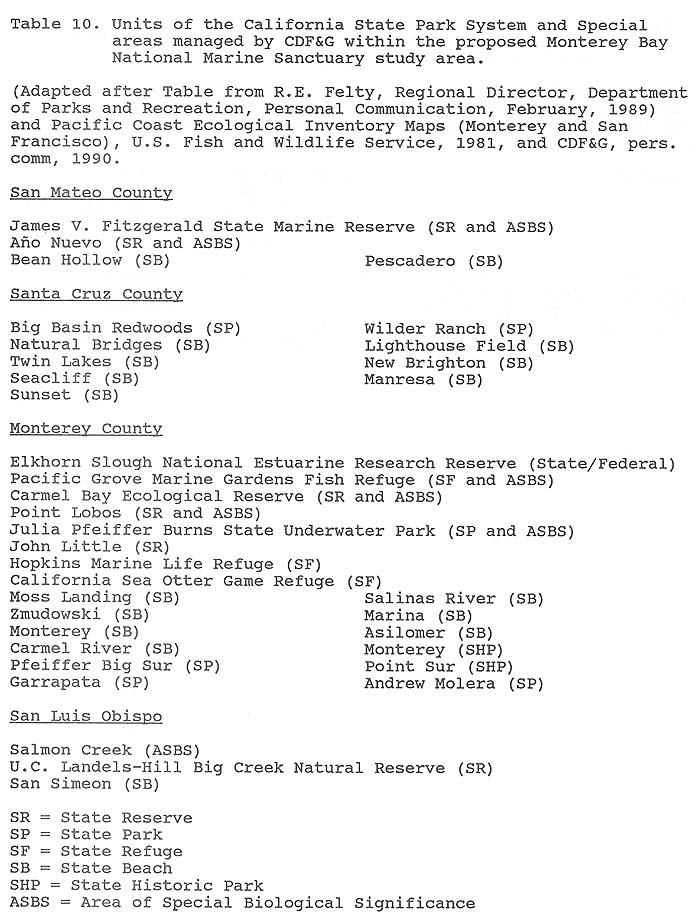
All of the state protected areas are designated by the State with the intent to protect significant local resources for either research, education or aesthetic purposes (Also see Recreation and Tourist, and Research and Education sections below). For example, certain restrictions apply to the taking of invertebrates in tide pools or other areas of the marine environment (Table 11). A brief discussion on the types of, and management regime for, the protected areas follows:
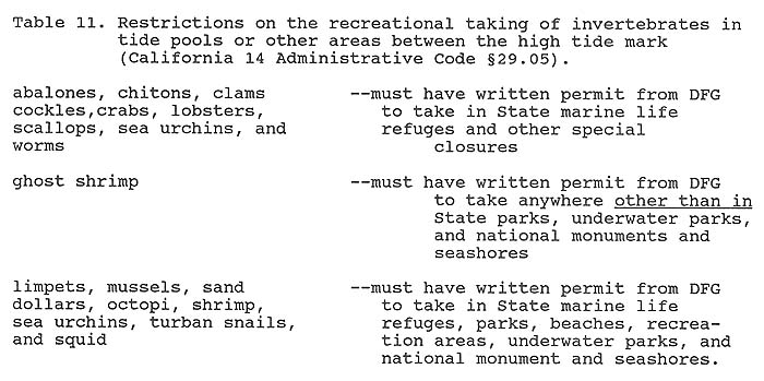
Table 10: California state park system
Table 11: Restrictions on recreational taking of invertebrates
1. State Refuges and Reserves [Part II TOC]
Several refuges and reserves for the protection of marine life have been established in the proposed sanctuary area by the California Department of Fish and Game. These areas fall into five general categories and relate to the type of resource and its specific protection needs; a) ecological reserves, b) game refuges, c) marine life refuges, d) fish refuges, and e) marine reserves. The general authority exercised by the Department of Fish and Game within each category and within specific refuges or reserves in the study area is as follows:
a. Ecological Reserves (California Fish and Game Code § 1580 et. seq.) [Part II TOC]
Of the state's protected areas, Ecological reserves provide the most comprehensive protection. Within these ecological reserves, the California Department of Fish and Game has the authority to prohibit any activity which may harm the resources, including: fishing, collecting, swimming, boating, low-flying aircraft, and public entry (14 California Administrative Code § 630 (a)). General regulations provide that "no person shall disturb geological reserves, formations or archaeological artifacts or take or disturb any bird or nest, or eggs thereof, or any plant, mammal, fish, mollusk, crustacean...or any other form of plant or animal life in an ecological reserve" (14 California Administrative Code §630(a)(1)). These prohibited activities may, however, be permitted by the Department of Fish and Game in particular reserves or in certain areas of particular concern pursuant to specific regulations.
Both Point Lobos and Carmel Bay are protected due to the fragility of the prevalent rocky tidepools. The areas are also heavily used by marine mammals and birds. Point Lobos is a favored roosting area for the endangered Brown Pelican (Association of Monterey Bay Area Governments, 1978). Efforts to protect the resources of Point Lobos reserves, including 750 acres (300 hectares) of underwater area, have been initiated by the California Department of Parks and Recreation (DPR). Because DPR lacks authority to prohibit fishing, however, the area was established as an ecological reserve rather than park. The reserve is managed primarily by DPR, which maintains a large, on-site staff, with DFG contributing as needed to enforcement efforts. All fishing is prohibited within the reserve. Swimming, boating and other aquatic sports are permitted. Boats, however, may be launched and retrieved only in designated areas and may be anchored only during daylight hours.
The Carmel Bay Ecological Reserve encompasses ocean waters of Carmel Bay extending approximately .75 sm (1.4 km) from the mean tide line to a line drawn across the bay from Granite Point to Pescadero Point. The reserve also includes the Pinnacles, a series of offshore rocks, and surrounding ocean waters less than 15 fathoms (28.3 meters) in depth. Carmel Bay marks the beginning of the California Sea Otter Refuge. The Bay is an important haulout and foraging area for otters and other marine mammals. The nearshore zone is typical kelp forest habitat, with the attendant abundance of marine life (Association of Monterey Bay Area Governments, 1978). While the DFG is primarily responsible for managing the reserve, DPR enforcement personnel from Point Lobos Ecological Reserve patrol the Bay.
Sport fishing with hook and line, spear gun, or hand-held implements is generally permitted within the reserve. No invertebrates may be taken, however. Swimming, boating, surfing, skin, and scuba diving are all permitted. Extensive restrictions apply to the harvesting of kelp. If, at any time, the DFG Director finds that the harvesting of kelp will tend to destroy or impair kelp beds, or tend to destroy or impair the supply of food for fish or wildlife, a notice that a particular kelp bed, or part of a bed, will be closed to the harvesting of kelp for period not to exceed one year, must be issued. At least 48 hours notice of the intention to harvest kelp within the reserve must be given the CDFG's regional manager. An observer of the CDFG may accompany the harvester. Other regulations apply to the harvesting of kelp on particular areas of the reserve.
b. Game Refuges (California Fish and Game Code §10500 et seq.) [Part II TOC]
It is unlawful in general to take or possess any bird or mammal or part thereof, in any game refuge [California Fish and Game Code § 10500]. In addition, the use or possession of any firearm, bow and arrow, or any trap or other contrivance designed to be or capable of being used to take birds or mammals is prohibited within a game refuge (California Fish and Game Code §10500). The Department of Fish and Game has complete authority to exercise control over all mammals other than marine mammals and birds in any game refuge, including the authority to issue permits for their taking (California Fish and Game Code §10502). In navigable water areas of game refuges, however, general regulations do not prohibit the taking of birds or mammals.
For example, the California Sea Otter Game Refuge covers portions of Monterey and San Luis Obispo Counties between the Carmel River on the north and the Santa Rosa Creek on the south, which lie west of California Highway 1 (California Fish and Game Code §10840). The refuge excludes coastal waters. It is the largest refuge in the state covering 86 nm (160 km) of coastline in Monterey County and 30 nm (56 km) in San Luis Obispo County (Association of Monterey Bay Area Governments, 1978). Within its boundaries are several state parks and reserves, including Point Lobos Ecological Reserve and the Julia Pfeiffer Burns State Park, and the entire Big Sur coastline. The refuge was primarily created to protect the threatened California Sea Otter, but it also protects important habitat for numerous marine birds and mammals (Association of Monterey Bay Area Governments, 1978). In addition to the general regulations described above, it is unlawful to fly any aircraft less than 1000 feet above the refuge. Lawful occupants of private lands located within the refuge may take otherwise unprotected birds and mammals on such lands without a permit.
c. Marine Life Refuges [California Fish and Game Code §10500(f)] [Part II TOC]
It is unlawful in a marine life refuge to take or possess any invertebrate or specimen of marine plant life. Such refuges are generally established to promote research activities. For example, the Hopkins Marine Life Refuge includes ocean waters extending 1000 feet from the mean high tide line adjacent to the eastern part of the city of Pacific Grove at the southern end of Monterey Bay (California Fish and Game Code §10901). Both the Hopkins and the Pacific Grove Marine Gardens Fish Refuge (see below) are established principally to protect the richness and sensitivity of the rocky intertidal ecology. The most important feature of both areas is the number of small rocky islands in the nearshore area, which provide resting and nesting places for marine birds and mammals, particularly the California Sea Otter. Associated with these rocky areas are dense beds of giant kelp (Association of Monterey Bay Area Governments, 1978). While the taking of invertebrates and marine plant life specimens is generally prohibited, officers, employees, students, and licensees of Stanford University and the University of California are permitted to do so for scientific purposes without a permit.
d. Fish Refuge [California Fish and Game Code §10500(c)] [Part II TOC]
The taking and possession of fish or amphibia and the use and possession of any contrivance designed to be used for catching fish are generally prohibited in a fish refuge. For example, the Pacific Grove Marine Gardens Fish Refuge includes ocean waters of Monterey Bay to a depth of 60 ft. (18.1 m) measured from mean low tide adjacent to the City of Pacific Grove. Its western and eastern boundaries correspond to extensions of the western and eastern corporate limits of the city. The Hopkins Marine Life Refuge falls within the boundaries of the fish refuge (California Fish and Game Code § 10801).
For management purposes the refuge is divided into two areas applying different regulations for the taking of fish in each area. In the western half of the refuge, abalone and sea urchin may be taken commercially, except that the area may be closed if it is determined that the depletion of these species will endanger the balance of marine life. Fish, other than mollusks and crustaceans, may be taken throughout the refuge pursuant to a sport fishing license. In addition, marine life may be taken for scientific purposes pursuant to an appropriate permit. Finally, sardines, mackerel, anchovies, squid, and herring may be taken by net or bait in both areas of the refuge.
e. Marine Reserves [Part II TOC]
Marine Reserves are established by the California Department of Fish and Game for a wide variety of purposes and, thus, no general regulations exist. Rather specific regulations for each reserve are designed to protect the unique forms of marine life peculiar to it. For example the Año Nuevo State Reserve consists of mainland areas on Año Nuevo Point, ocean waters stretching 100 ft. (30.4 m) from the low tide mark adjacent to those areas, and Año Nuevo Island. The reserve is managed by the State Department of Parks and Recreation, due to the large numbers of visitors it receives. The entire area of the reserve is owned by the state. The basic purpose for its establishment is to encourage the reintroduction of pinniped populations and to protect them from human disturbance.
Regulations prohibit the taking of invertebrates on the mainland shore between the high tide mark and 100 feet beyond the low tide mark [14 California Administrative Code § 29.05(b)(3)]. In addition, it is unlawful to fly aircraft less than 1,000 feet above the land and water area of the reserve (California Fish and Game Code §10501.5).
Regional Water Quality Control Boards (RWQCBs) are responsible for integrating Areas of Special Biological Significance (ASBS) designations into their area wide basin plans, which outline waste discharge prohibitions and restrictions. A routine ASBS reconnaissance survey conducted by the State Water Resources Control Board (SWRCB) provides RWQCBs with detailed resource information as well as data on existing or future uses that are apt to threaten ASBS environmental quality. ASBS surveillance and monitoring by RWQCBs ensures compliance with discharge regulations in the broader context of basin wide enforcement. Should either an actual discharge violation or a threat thereof become apparent, the regional board is empowered with specific administrative procedures and remedies to enforce compliance (see California Water Code, Section 13300).
The following ASBSs have been designated within the study area:
(1) Año Nuevo Point and Island: This ASBS includes ocean waters extending 3 nm (5.6 km) from the mean high tide line on the mainland coast bounded on the north by a line extending southwest from the San Mateo-Santa Cruz County line. The ASBS thus covers a considerably larger area than the Año Nuevo State Reserve.
(2) Pacific Grove Marine Gardens Fish Refuge and Hopkins Marine Life Refuge: This ASBS includes ocean waters contained within the Pacific Grove Marine Gardens Fish Refuge (see above).
(3) Carmel Bay: This ASBS includes waters contained within the Carmel Bay Ecological Reserve (see above).
(4) Point Lobos Ecological Reserve: This ASBS includes ocean waters contained within the Point Lobos Ecological Reserve (see above).
(5) Julia Pfeiffer Burns Underwater Park: This ASBS includes ocean waters contained within the Julia Pfeiffer Burns Underwater Park (see below).
(6) Ocean Area Surrounding the Mouth of the Salmon Creek: This ASBS includes ocean waters extending from the mean high tide line to the 100-foot isobath or 1000 feet offshore, whichever is greater between the Monterey-San Luis Obispo County line and a point approximately five miles north. This is the only ASBS in the study area that does not correspond to a state refuge, reserve, or underwater park. It was established primarily to protect fragile rocky intertidal and kelp forest habitat.
2. State Historic Parks (California Public Resources Code §5020.4) [Part II TOC]
Preservation of representative and unique archeological, paleontological, and historical sites in the land and water areas of the state is the responsibility of the California Historical Resources Commission. The Commission evaluates and makes recommendations to the State Historic Preservation Officer on nominations to the National Register (see Section on Historic Resources above for nominated sites).
The Commission also recommends state registration of sites as landmarks and points of interest to the Public Resources Department which is responsible for maintenance of registered sites (California Public Resources Code §5020.4). Registration as a point of interest is normally accompanied by the placement of informational signs. Landmarks, along with properties listed on the National Register and city or county registers or inventories, become eligible for qualified historic property status for which special protection may be afforded (California Public Resources Code §5031). At present, no sites within the study area have been registered as either landmarks or points of interest.
3. California State Park System and Beaches [Part II TOC]
The California Department of Parks and Recreation is responsible for managing State Parks and Beaches for their recreational and aesthetic value (Table 10). However, in order to protect special marine resources and water-based recreational values in ocean waters within state jurisdiction and to expand coastal park units beyond the water's edge, the California Department of Parks and Recreation has established an Underwater Parks Program. For example, Point Lobos Ecological Reserve, the first underwater park in the United States, was established in 1960. As described above, while the DPR manages the reserve, it is operated under the legal authority of the Fish and Game Code.
Julia Pfeiffer Burns State Park, on the other hand, is both owned and operated by the DPR. The underwater park contains 2.6 nm (4.9 km) of coastline and adjacent ocean waters and submerged lands between Partington Point and McWay Rock Falls. It is managed in conjunction with the adjacent land-based park. There are no regulations on recreational activities. Instead, visitation is controlled by a permit system; and permits are usually only given to clubs with an experienced diving master. Several other locations are currently under consideration for designation as underwater parks. These include expansions of Point Lobos and Julia Pfeiffer Burns and new parks at Año Nuevo State Reserve, Wilder Ranch State Park and Cannery Row.